IMAGES TAKEN NEAR TO
Stoke Hill, BRISTOL, BS9 1ER
Introduction
This page details the photographs taken nearby to Stoke Hill, BS9 1ER by members of the Geograph project.
The Geograph project started in 2005 with the aim of publishing, organising and preserving representative images for every square kilometre of Great Britain, Ireland and the Isle of Man.

There are currently over 7.5m images from over14,400 individuals and you can help contribute to the project by visiting https://www.geograph.org.uk
Image Map
Images are licensed for reuse under creativecommons.org/licenses/by-sa/2.0
Notes
- Clicking on the map will re-center to the selected point.
- The higher the marker number, the further away the image location is from the centre of the postcode.
Image Listing (28 Images Found)
Images are licensed for reuse under creativecommons.org/licenses/by-sa/2.0
Image
Details
Distance
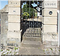
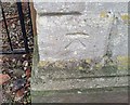
1
Ordnance Survey Cut Mark
This OS cut mark can be found on the gatepost of No44 Stoke Hill. It marks a point 33.641m above mean sea level.
Image: © Adrian Dust
Taken: 8 Oct 2021
0.04 miles
2

Double benchmark detail
This is a close-up of the bottom of the gatepost in Image
Image: © Neville Goodman
Taken: 11 Jun 2017
0.05 miles
3
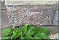
A double benchmark
There is a benchmark in the OS database, description P ENT NO44 STOKE HILL. It is on the stone next to bottom on the right-hand gatepost. On closer inspection Image, it is a double mark, and I'm not sure which one is the database mark.
Image: © Neville Goodman
Taken: 11 Jun 2017
0.05 miles
8
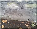
Ordnance Survey Cut Mark
This OS cut mark can be found on the wall SW side of Stoke Hill. It marks a point 49.173m above mean sea level.
Image: © Adrian Dust
Taken: 8 Oct 2021
0.17 miles
9
Ordnance Survey Cut Mark
This OS cut mark can be found on the gatepost north side of Holly Bush Lane. It marks a point 42.194m above mean sea level.
Image: © Adrian Dust
Taken: 17 Jan 2020
0.18 miles
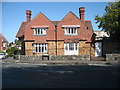
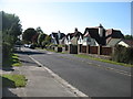
10

Detached houses on Druid Stoke Avenue
For once, a section of street, missed by Google Maps!
Image: © Roger Cornfoot
Taken: 7 Oct 2020
0.19 miles