IMAGES TAKEN NEAR TO
Sea Mills Lane, BRISTOL, BS9 1DN
Introduction
This page details the photographs taken nearby to Sea Mills Lane, BS9 1DN by members of the Geograph project.
The Geograph project started in 2005 with the aim of publishing, organising and preserving representative images for every square kilometre of Great Britain, Ireland and the Isle of Man.

There are currently over 7.5m images from over14,400 individuals and you can help contribute to the project by visiting https://www.geograph.org.uk
Image Map
Images are licensed for reuse under creativecommons.org/licenses/by-sa/2.0
Notes
- Clicking on the map will re-center to the selected point.
- The higher the marker number, the further away the image location is from the centre of the postcode.
Image Listing (35 Images Found)
Images are licensed for reuse under creativecommons.org/licenses/by-sa/2.0
Image
Details
Distance
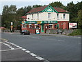
3
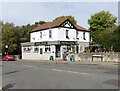
Paul Burns Photography on Shirehampton Road, Sea Mills
Image: © David Howard
Taken: 1 Jun 2019
0.11 miles
4
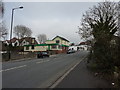
Shirehampton Road
Near the junction with Bell Barn Road, Sea Mills
Image: © Peter Barr
Taken: 6 Feb 2010
0.11 miles
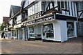
6
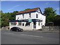
The Mill House
On Shirehampton Road near its junction with Bell Barn Road
Image: © Eirian Evans
Taken: 19 Sep 2017
0.12 miles
7
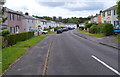
NE section of Trym Side, Sea Mills, Bristol
Trym Side houses viewed from the corner of Meadway.
Image: © Jaggery
Taken: 23 Jun 2012
0.12 miles
8
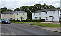
Houses on a bend in Trym Side, Sea Mills, Bristol
This is the northern section of the residential road Trym Side.
Image: © Jaggery
Taken: 23 Jun 2012
0.12 miles
9
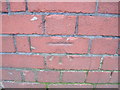
Ordnance Survey Cut Mark
This mark can be found on the wall of 94 Shirehampton Road.
For more details see : http://www.bench-marks.org.uk/bm41588
Image: © Peter Wood
Taken: 23 Feb 2012
0.12 miles
10
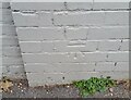
Ordnance Survey Cut Mark
This OS cut mark can be found on No94 Shirehampton Road. It marks a point 13.695m above mean sea level.
Image: © Adrian Dust
Taken: 8 Oct 2021
0.13 miles