IMAGES TAKEN NEAR TO
BRISTOL, BS8 9HY
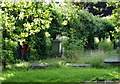
Introduction
This page details the photographs taken nearby to BS8 9HY by members of the Geograph project.
The Geograph project started in 2005 with the aim of publishing, organising and preserving representative images for every square kilometre of Great Britain, Ireland and the Isle of Man.

There are currently over 7.5m images from over14,400 individuals and you can help contribute to the project by visiting https://www.geograph.org.uk
Image Map
Images are licensed for reuse under creativecommons.org/licenses/by-sa/2.0
Notes
- Clicking on the map will re-center to the selected point.
- The higher the marker number, the further away the image location is from the centre of the postcode.
Image Listing (429 Images Found)
Images are licensed for reuse under creativecommons.org/licenses/by-sa/2.0
Image
Details
Distance
1
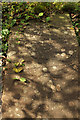
Tombstone, St Andrew's churchyard, Bristol
Honeysuckle trails over an inscribed stone in the churchyard.
Image: © Derek Harper
Taken: 3 Oct 2018
0.02 miles
2
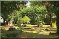
St Andrew's churchyard, Bristol
The eastern side of the churchyard.
Image: © Derek Harper
Taken: 3 Oct 2018
0.02 miles
3
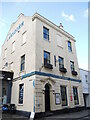
The Lansdown in Clifton
A pub and former hotel since Georgian times.
Image: © Neil Owen
Taken: 4 Mar 2022
0.02 miles
4
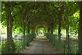
Clifton Hill Area - BS8
A section of the picturesque St Andrew's Walk footpath between Clifton Hill and The Fosseway corner of Victoria Square. This short-cut slices through the overgrown graveyard and passing under a long arcade of trees, allows students in particular to use this as a means of accessing Queen’s Road from the Halls of Residence situated on the other side of Clifton Hill. The path also allows pedestrians and cyclists a view of the site of the former St Andrew’s churches, of which there were three between 1600-1959. A grassed area and a memorial stone at the Clifton Hill end of the path marks the place where the churches stood.
Image: © David Hallam-Jones
Taken: 1 Aug 2012
0.03 miles
5
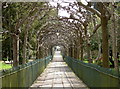
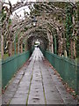
Wrapping around the walkers
Church Walk is a path that bisects the graveyards of the former St Andrew's church - originally the principal church of the village of Clifton. It is better known locally as Birdcage Walk and the view here gives a good impression in support of it. The name goes back some time; nearby contemporary Victoria Square also had railings but these were taken down to contribute to the war effort. Interestingly, the more extensive railings and supports are still here in Church Walk - perhaps the prestige of the path (and the heavy foliage!) prevented the iron going to the furnaces.
Image: © Neil Owen
Taken: 10 Apr 2015
0.03 miles
6
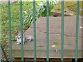
'Sorry to bother you, but do you have any nuts?'
A cheeky character appears close to the path known locally as Birdcage Walk. The old graveyard is a quiet and largely undisturbed area in Clifton, protected from the city's traffic and bustle. Plenty of people pass by and occasionally take a few moments' relaxation. Perhaps some of the passers-by have tended to offer food, too.
Image: © Neil Owen
Taken: 10 Apr 2015
0.03 miles
7
Birdcage Walk, Bristol
Also known as St Andrew's Walk, since it runs through the former churchyard of St Andrew's, and as footpath BCC 286/10. "A good flagged path through the former churchyard of St Andrew's with wrought-iron railings either side" https://www.historicengland.org.uk/listing/the-list/list-entry/1282135 .
Image: © Derek Harper
Taken: 25 Jun 2017
0.03 miles
8
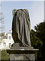
Headless gravestone
A sad figure, perhaps an angel, is missing an important piece of stonework.
Image: © Neil Owen
Taken: 10 Apr 2015
0.03 miles
9
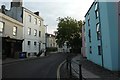
Clifton Road
Looking along Clifton Road in the early morning.
Image: © DS Pugh
Taken: 22 Aug 2019
0.04 miles