IMAGES TAKEN NEAR TO
Cornwallis Crescent, BRISTOL, BS8 4PL
Introduction
This page details the photographs taken nearby to Cornwallis Crescent, BS8 4PL by members of the Geograph project.
The Geograph project started in 2005 with the aim of publishing, organising and preserving representative images for every square kilometre of Great Britain, Ireland and the Isle of Man.

There are currently over 7.5m images from over14,400 individuals and you can help contribute to the project by visiting https://www.geograph.org.uk
Image Map
Images are licensed for reuse under creativecommons.org/licenses/by-sa/2.0
Notes
- Clicking on the map will re-center to the selected point.
- The higher the marker number, the further away the image location is from the centre of the postcode.
Image Listing (687 Images Found)
Images are licensed for reuse under creativecommons.org/licenses/by-sa/2.0
Image
Details
Distance
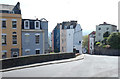
1
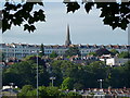
View of the heights of Clifton from Ashton Bridge
The spire of Christ Church Image is prominent on the skyline, with houses at Clifton Wood and Hotwells in the foreground.
Image: © Anthony O'Neil
Taken: 9 Jul 2010
0.01 miles
2
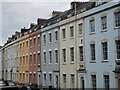
Cornwallis Crescent
Hotwells, Bristol
Image: © Anthony O'Neil
Taken: 23 May 2017
0.01 miles
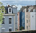
3
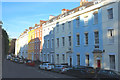
Cornwallis Crescent, Bristol
Familiar colourful Bristolian Georgian terrace, each of the twenty-four houses of three bays, the windows topped by stepped voussoirs. Its gentle curve follows that of Royal York Crescent just up the hill (Image]). Built c1791-c1835, perhaps by William Paty. Grade II* listed.
Image: © Stephen Richards
Taken: 22 May 2012
0.01 miles
4
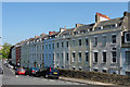
Colours of Cornwallis Crescent
Bristol has become home to many various shades.
Image: © Neil Owen
Taken: 13 Oct 2021
0.03 miles

6
Houses of Clifton (9)
Cornwallis Crescent
Image: © Anthony O'Neil
Taken: 15 Apr 2020
0.04 miles
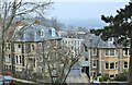
7
Colourful high rises
Granby Hill, Clifton
Image: © Anthony O'Neil
Taken: 24 May 2021
0.04 miles
8
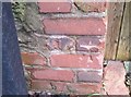
Ordnance Survey Cut Mark
This OS cut mark can be found on the wall east side of Polygon Lane. It marks a point 31.416m above mean sea level.
Image: © Adrian Dust
Taken: 3 Jan 2020
0.04 miles
10
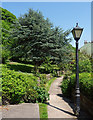
Cedar, The Polygon, Bristol
Its blue-green colouring suggests it is an example of the glaucous form of the Atlantic or Atlas cedar (Cedrus atlantica).
Image: © Stephen Richards
Taken: 22 May 2012
0.04 miles