IMAGES TAKEN NEAR TO
Cornwallis Crescent, BRISTOL, BS8 4PH
Introduction
This page details the photographs taken nearby to Cornwallis Crescent, BS8 4PH by members of the Geograph project.
The Geograph project started in 2005 with the aim of publishing, organising and preserving representative images for every square kilometre of Great Britain, Ireland and the Isle of Man.

There are currently over 7.5m images from over14,400 individuals and you can help contribute to the project by visiting https://www.geograph.org.uk
Image Map
Images are licensed for reuse under creativecommons.org/licenses/by-sa/2.0
Notes
- Clicking on the map will re-center to the selected point.
- The higher the marker number, the further away the image location is from the centre of the postcode.
Image Listing (523 Images Found)
Images are licensed for reuse under creativecommons.org/licenses/by-sa/2.0
Image
Details
Distance
2
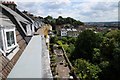
View from Cornwallis Crescent
View from a flat on the top flat of Cornwallis Crescent in Bristol.
Image: © Philip Halling
Taken: 29 Jun 2014
0.01 miles
3
View from Cornwallis Crescent
View from a top flat flat on Cornwallis Crescent.
Image: © Philip Halling
Taken: 29 Jun 2014
0.02 miles
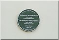
4
Ordnance Survey Cut Mark
This OS cut mark can be found on the wall north side of Cornwallis Crescent. It marks a point 49.915m above mean sea level.
Image: © Adrian Dust
Taken: 3 Jan 2020
0.02 miles
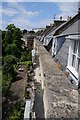
5
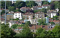
Houses on the hillside at Hotwells, Bristol
Image: © Anthony O'Neil
Taken: 9 Jul 2010
0.03 miles
6
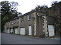
Garages on Cornwallis Crescent
A block of garages converted from The Cottages. See Image] for a close look at the corner stone - a benchmark can be found.
Image: © Neil Owen
Taken: 13 Oct 2021
0.03 miles
7
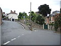
One of Clifton's tightest bends
As Goldney Avenue drops down the hill and meets Cornwallis Crescent, the road takes a severe hairpin bend and becomes Clifton Vale. It's been the scene of many a furrowed brow.
Image: © Neil Owen
Taken: 13 Oct 2021
0.04 miles
8
Ordnance Survey Cut Mark
This OS cut mark can be found on the garage north side of Cornwallis Crescent. It marks a point 44.921m above mean sea level.
Image: © Adrian Dust
Taken: 3 Jan 2020
0.04 miles
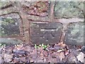
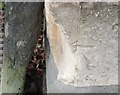
9
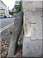
Marks on a dangerous corner
This benchmark on the corner of the old cottages at the end of Cornwallis Crescent has suffered some passing damage. It appears to be a second mark made on this spot; the first was facing towards the crescent and is no longer extant. The second is going the same way! See Image] for a wider view and https://www.bench-marks.org.uk/bm66803 for the entry in the Benchmark Database.
Image: © Neil Owen
Taken: 13 Oct 2021
0.04 miles
10
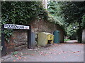
Polygon Lane
An odd name for a lane off Cornwallis Crescent perhaps, until you realise it leads down to The Polygon and Polygon Road - the area they bound is somewhat irregular in shape. The lane is actually quite an old one, appearing on maps of the early 1800s.
Image: © Neil Owen
Taken: 13 Oct 2021
0.04 miles