IMAGES TAKEN NEAR TO
Clifton Down Road, BRISTOL, BS8 4AJ
Introduction
This page details the photographs taken nearby to Clifton Down Road, BS8 4AJ by members of the Geograph project.
The Geograph project started in 2005 with the aim of publishing, organising and preserving representative images for every square kilometre of Great Britain, Ireland and the Isle of Man.

There are currently over 7.5m images from over14,400 individuals and you can help contribute to the project by visiting https://www.geograph.org.uk
Image Map
Images are licensed for reuse under creativecommons.org/licenses/by-sa/2.0
Notes
- Clicking on the map will re-center to the selected point.
- The higher the marker number, the further away the image location is from the centre of the postcode.
Image Listing (571 Images Found)
Images are licensed for reuse under creativecommons.org/licenses/by-sa/2.0
Image
Details
Distance
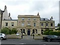
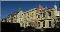
1
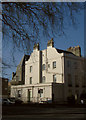
Rodney House, Clifton
The listed house "with swept coped gables" https://historicengland.org.uk/listing/the-list/list-entry/1202098 is at the corner of Portland Street with Clifton Down Road. Listed as "House, now college"; now offices.
Image: © Derek Harper
Taken: 25 Feb 2019
0.01 miles
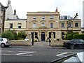
2
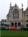
Guardian Court
This building was formerly Clifton Down Clifton United Reformed Church but has now been converted to flats. Built in Gothic Revival style.
Image: © Eirian Evans
Taken: 20 Nov 2010
0.02 miles
3
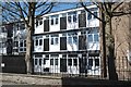
Bristol Apartments (25)
International House, Clifton
Image: © Anthony O'Neil
Taken: 13 Apr 2020
0.03 miles
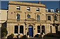
4
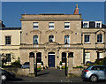
Freemantle House, Clifton Down Road, Bristol
Under the Victorian overcoat, courtesy of Charles Hansom in 1884, is a mid-Georgian house, more obvious at the top storey. Grade II listed.
Image: © Stephen Richards
Taken: 22 May 2012
0.03 miles
5
York House, Freemantle House and Worsley House
Built – clearly in stages – as a single house with the name Rodney Lodge (as shown in the Listing description), but currently three separate units. The original 1770 house was extended and altered in 1884 by C Hansom. Listed Grade II.
Image: © Alan Murray-Rust
Taken: 25 Jun 2017
0.03 miles
6
Freemantle House
Built circa 1770, this Palladian House was much altered in the late 19th century. Once known as Rodney Lodge and at one time a college, the property is now apartments. Listed, grade II, with details at: https://www.historicengland.org.uk/listing/the-list/list-entry/1205803
Image: © Michael Dibb
Taken: 25 Jun 2017
0.03 miles
7
Freemantle House, Clifton
See also images at http://www.geograph.org.uk/search.php?i=95446144 . The striking house is described (as Rodney Lodge) at https://historicengland.org.uk/listing/the-list/list-entry/1205803 .
Image: © Derek Harper
Taken: 25 Feb 2019
0.03 miles
8
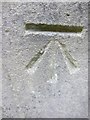
Ordnance Survey Cut Mark
This OS cut mark can be found on the front of the Clifton Congregational Church, Suspension Bridge Road. It marks a point 261.60ft above mean sea level.
Image: © Adrian Dust
Taken: 30 Nov 2013
0.03 miles
9
Houses on Clifton Down Road
Including, in the centre, Freemantle House (listed as Rodney Lodge https://historicengland.org.uk/listing/the-list/list-entry/1205803 and shown in the images at http://www.geograph.org.uk/search.php?i=95446144 ).
Image: © Derek Harper
Taken: 25 Feb 2019
0.03 miles
10
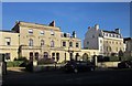
Houses on Clifton Down Road
This is the B3129. On the right is the former Walker Dunbar Hospital http://list.historicengland.org.uk/resultsingle.aspx?uid=1202100&searchtype=mapsearch , founded by Eliza Walker Dunbar (1845-1925), Bristol’s first resident female house surgeon. To its left, with a carriage entrance is the Coach House, the former stables http://list.historicengland.org.uk/resultsingle.aspx?uid=1202099&searchtype=mapsearch to Rodney Lodge, which is the imposing house left of centre http://list.historicengland.org.uk/resultsingle.aspx?uid=1205803&searchtype=mapsearch (mapped as Freemantle House).
Image: © Derek Harper
Taken: 22 Mar 2015
0.03 miles