IMAGES TAKEN NEAR TO
Birchwood Drive, BRISTOL, BS8 3UZ
Introduction
This page details the photographs taken nearby to Birchwood Drive, BS8 3UZ by members of the Geograph project.
The Geograph project started in 2005 with the aim of publishing, organising and preserving representative images for every square kilometre of Great Britain, Ireland and the Isle of Man.

There are currently over 7.5m images from over14,400 individuals and you can help contribute to the project by visiting https://www.geograph.org.uk
Image Map
Images are licensed for reuse under creativecommons.org/licenses/by-sa/2.0
Notes
- Clicking on the map will re-center to the selected point.
- The higher the marker number, the further away the image location is from the centre of the postcode.
Image Listing (25 Images Found)
Images are licensed for reuse under creativecommons.org/licenses/by-sa/2.0
Image
Details
Distance
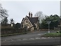
1
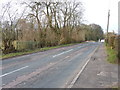
Weston Road, Failand
The green, fenced enclosure on the left (OK, yes, it does resemble a baby's playpen) houses the Flax Bourton Fundamental Benchmark http://www.bench-marks.org.uk/bm1062 and http://www.trigpointinguk.com/trigs/trig-details.php?t=7221 Image
Image: © Richard Law
Taken: 4 Apr 2013
0.03 miles
2
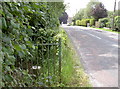
Fundamental benchmark, Weston Road, Failand
An Ordnance Survey monument, with its own railings to protect it. See Image] for a closer view.
Image: © Neil Owen
Taken: 28 Jul 2011
0.05 miles
3
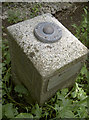
Fundamental Benchmark, Flax Bourton
Although sited at the outskirts of Failand, near Bristol, this is the important levelling monument for the area. It was first measured very accurately during the Second Geodetic Levelling of England and Wales in the early part of the Twentieth century to a height of 141.8487 metres (465.3830 feet) above Newlyn sea level.
See http://www.bench-marks.org.uk/bm1062 for the Benchmark Database, and Image] for a location view.
Image: © Neil Owen
Taken: 28 Jul 2011
0.05 miles
4
Junction of Weston Road and Flax Bourton Road
Image: © Richard Law
Taken: 4 Apr 2013
0.06 miles
5
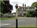
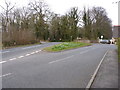
Direction Sign ? Signpost on the B3129 Weston Road
Located on a grass triangle at the junction of the B3129 Weston Road and Flax Bourton Road in Wraxall and Failand parish. 3 arms and pyramid finial.
Milestone Society National ID: SO_ST5171
Image: © Roadside Relics
Taken: 22 Jun 2021
0.06 miles
6

Deep snow drift across the B3129 at the top of Belmont Hill, Failand
Image: © Colin Park
Taken: 20 Feb 1978
0.06 miles
7
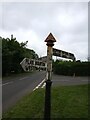
Fingerpost at Failand
Fingerpost at Failand on the corner of Flax Bourton Road and Weston Road. The signs point to Lower Failand 1½, Village Hall & Church on one, Flax Bourton 1½ and Weston-s-Mare 16 on another, and Clifton via Toll Bridge and Abbots Leigh on the other.
Image: © s
Taken: 23 Aug 2021
0.07 miles
9
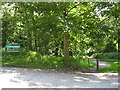
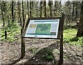
Ashton Hill car park
The sign and car park for, and main entrance path into Ashton Hill Plantation
Image: © George Evans
Taken: 13 Jul 2008
0.09 miles
10
In the forest (1)
Near Clifton Lodge
Image: © Anthony O'Neil
Taken: 5 Apr 2021
0.09 miles