IMAGES TAKEN NEAR TO
Manor Lane, BRISTOL, BS8 3RY
Introduction
This page details the photographs taken nearby to Manor Lane, BS8 3RY by members of the Geograph project.
The Geograph project started in 2005 with the aim of publishing, organising and preserving representative images for every square kilometre of Great Britain, Ireland and the Isle of Man.

There are currently over 7.5m images from over14,400 individuals and you can help contribute to the project by visiting https://www.geograph.org.uk
Image Map
Images are licensed for reuse under creativecommons.org/licenses/by-sa/2.0
Notes
- Clicking on the map will re-center to the selected point.
- The higher the marker number, the further away the image location is from the centre of the postcode.
Image Listing (43 Images Found)
Images are licensed for reuse under creativecommons.org/licenses/by-sa/2.0
Image
Details
Distance
1
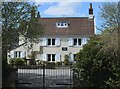
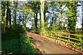
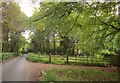
Manor Lane
Single track: Abbots Leigh
Image: © Anthony O'Neil
Taken: 15 Apr 2021
0.02 miles
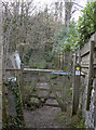
2
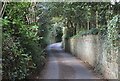
A short path to the other paths
This little criss-cross of footpaths on Manor Lane form a neat square with diagonals. In the past, Manor Lane stopped and the paths took over, but in latter days it was extended and so consumed some old routes. This narrow path simply goes about 50m before joining up; the modern road rather negates its need.
Image: © Neil Owen
Taken: 16 Feb 2018
0.08 miles
3
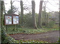
Village notice board on the Gordano Round path
The Gordano Round long distance path is a broadly figure-of-eight route that stretches from the coast at Portishead and Clevedon, and reaches as far inland as Abbot's Leigh. Here the path is at its easternmost extent and encounters a notice board. The house beyond in the trees appears abandoned and shut.
Image: © Neil Owen
Taken: 16 Feb 2018
0.10 miles
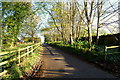
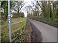
4
Manor Lane, Abbot's Leigh
Lane through woodland west of Bristol.
Image: © Jonathan Billinger
Taken: 9 Nov 2014
0.10 miles
5
Path to Abbot's Pool
This wooded area near Bristol has an ancient past involving some fish ponds that supplied the local Augustinian monastery. Nowadays the secluded woodlands are a popular place of recreation and a noticeboard explains lots of details. Part of the Gordano Round path network.
Image: © Neil Owen
Taken: 16 Feb 2018
0.10 miles
6
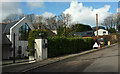
Houses on Knightcott Road, Abbots Leigh
A cul-de-sac off Sandy Lane.
Image: © Derek Harper
Taken: 17 Mar 2022
0.11 miles
7
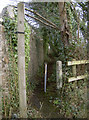
Manor Road, Abbot's Leigh
North from the junction with Manor Lane.
Image: © Jonathan Billinger
Taken: 9 Nov 2014
0.11 miles
8
Manor Road, Abbot's Leigh
A reverse view of Image, looking away from the village. The Monarch's Way follows the lane, while footpath LA1 4/80 branches off on the right.
Image: © Derek Harper
Taken: 23 Sep 2014
0.11 miles
9
Manor Road and Route 334
Cycle route 334, taking in Abbot's Leigh after starting from Portbury, a few miles west.
Image: © Neil Owen
Taken: 16 Feb 2018
0.12 miles