IMAGES TAKEN NEAR TO
Cypress Gardens, Burwalls Road, BRISTOL, BS8 3PS
Introduction
This page details the photographs taken nearby to Cypress Gardens, Burwalls Road, BS8 3PS by members of the Geograph project.
The Geograph project started in 2005 with the aim of publishing, organising and preserving representative images for every square kilometre of Great Britain, Ireland and the Isle of Man.

There are currently over 7.5m images from over14,400 individuals and you can help contribute to the project by visiting https://www.geograph.org.uk
Image Map
Images are licensed for reuse under creativecommons.org/licenses/by-sa/2.0
Notes
- Clicking on the map will re-center to the selected point.
- The higher the marker number, the further away the image location is from the centre of the postcode.
Image Listing (205 Images Found)
Images are licensed for reuse under creativecommons.org/licenses/by-sa/2.0
Image
Details
Distance
2
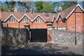
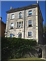
Bridge Road houses in Leigh Woods
A variety of house size and type on the south side of Bridge Road.
These houses in the North Somerset village are unnumbered, identified by name.
Image: © Jaggery
Taken: 7 May 2012
0.06 miles
3
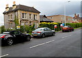
Leigh Woods : Burwalls Road
Houses on Burwalls Road in Leigh Woods.
Image: © Lewis Clarke
Taken: 24 Mar 2015
0.07 miles
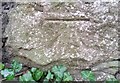
6
Ordnance Survey Cut Mark
This OS cut mark can be found on the NW side of Leighside Bridge Road. It marks a point 92.644m above mean sea level.
Image: © Adrian Dust
Taken: 26 Jul 2022
0.09 miles
7
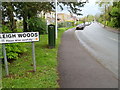
Leigh Woods boundary sign
Leigh Woods in North Somerset is the nearest village to the west side of Clifton Suspension Bridge.
Image: © Jaggery
Taken: 7 May 2012
0.10 miles
9
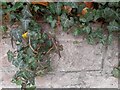
Ordnance Survey Cut Mark
This OS cut mark can be found on the NE wall on Burwalls Road. It marks a point 63.331m above mean sea level.
Image: © Adrian Dust
Taken: 23 Nov 2016
0.10 miles
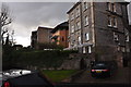
10
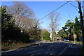
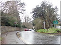
Bridge Road approaching Clifton Suspension Bridge
Image: © Tim Heaton
Taken: 9 Feb 2016
0.11 miles