IMAGES TAKEN NEAR TO
The Promenade, Clifton Down, BRISTOL, BS8 3NG
Introduction
This page details the photographs taken nearby to The Promenade, Clifton Down, BS8 3NG by members of the Geograph project.
The Geograph project started in 2005 with the aim of publishing, organising and preserving representative images for every square kilometre of Great Britain, Ireland and the Isle of Man.

There are currently over 7.5m images from over14,400 individuals and you can help contribute to the project by visiting https://www.geograph.org.uk
Image Map
Images are licensed for reuse under creativecommons.org/licenses/by-sa/2.0
Notes
- Clicking on the map will re-center to the selected point.
- The higher the marker number, the further away the image location is from the centre of the postcode.
Image Listing (249 Images Found)
Images are licensed for reuse under creativecommons.org/licenses/by-sa/2.0
Image
Details
Distance
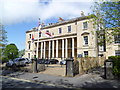
1
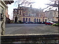
Merchants Hall, Clifton Down
The headquarters of the Society of Merchant Venturers, a charitable organisation in Bristol. The society can be traced back to a 13th century guild which funded the voyage of John Cabot to Canada. https://en.wikipedia.org/wiki/Society_of_Merchant_Venturers
Image: © Eirian Evans
Taken: 4 Mar 2019
0.01 miles
2
Merchants Hall, Clifton Down
The headquarters of the Society of Merchant Venturers, a charitable organisation in Bristol. The society can be traced back to a 13th century guild which funded the voyage of John Cabot to Canada. https://en.wikipedia.org/wiki/Society_of_Merchant_Venturers
Image: © Eirian Evans
Taken: 4 Mar 2019
0.01 miles
3
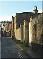
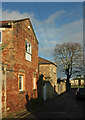
Litfield Road, Clifton
The curving urban lane links Canynge Road to Percival Road, passing several cottages.
Image: © Derek Harper
Taken: 26 Dec 2021
0.02 miles
4
How much is that doggie....
.. on the veranda! Grommit has found a new home on Clifton Down.
Image: © Eirian Evans
Taken: 4 Mar 2019
0.02 miles
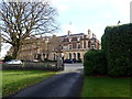
5
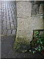
Cut Mark: Bristol, Clifton Down, Trigon House
Cut bench mark on a gatepost of Trigon House, previously known as Cote House. See http://www.geograph.org.uk/photo/5661936 for a wider view and http://www.bench-marks.org.uk/bm92134 for details.
Image: © Brian Westlake
Taken: 20 Jan 2018
0.04 miles
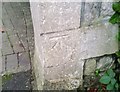
6
Cut Mark: Bristol, Clifton Down, Trigon House
Cut bench mark on a gatepost of Trigon House, previously known as Cote House. See http://www.geograph.org.uk/photo/5661931 for a closer view and http://www.bench-marks.org.uk/bm92134 for details.
Image: © Brian Westlake
Taken: 20 Jan 2018
0.04 miles
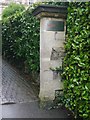
7
Ordnance Survey Cut Mark
This OS cut mark can be found on the gatepost of Cote House, Clifton Down. It marks a point 70.421m above mean sea level.
Image: © Adrian Dust
Taken: 2 Jan 2020
0.04 miles
8
Naval establishment in Clifton
Nice to see the white ensign flying in the breeze today here.
Image: © Jeremy Bolwell
Taken: 9 May 2015
0.05 miles
9
Litfield Road, Clifton
Two cottages by the side of the lane also shown in Image In the background is the tree shown in Image
Image: © Derek Harper
Taken: 26 Dec 2021
0.05 miles
10

Promenade in Clifton
Looking along the Promenade in Clifton, an avenue of Beech trees running parallel to the road.
Image: © Linda Bailey
Taken: 20 Nov 2006
0.05 miles