IMAGES TAKEN NEAR TO
Litfield Place, Clifton Down, BRISTOL, BS8 3LX
Introduction
This page details the photographs taken nearby to Litfield Place, Clifton Down, BS8 3LX by members of the Geograph project.
The Geograph project started in 2005 with the aim of publishing, organising and preserving representative images for every square kilometre of Great Britain, Ireland and the Isle of Man.

There are currently over 7.5m images from over14,400 individuals and you can help contribute to the project by visiting https://www.geograph.org.uk
Image Map
Images are licensed for reuse under creativecommons.org/licenses/by-sa/2.0
Notes
- Clicking on the map will re-center to the selected point.
- The higher the marker number, the further away the image location is from the centre of the postcode.
Image Listing (675 Images Found)
Images are licensed for reuse under creativecommons.org/licenses/by-sa/2.0
Image
Details
Distance
1
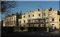
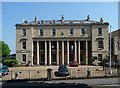
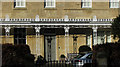
Listed buildings, Clifton Down
On the right is the pair of attached houses described at https://historicengland.org.uk/listing/the-list/list-entry/1280360 . On the left is Dorset House, the grade II* listed building also shown at https://www.geograph.org.uk/gridref/ST5673?centi=ST566733 and described at https://historicengland.org.uk/listing/the-list/list-entry/1282215 .
Image: © Derek Harper
Taken: 25 Feb 2019
0.01 miles
2
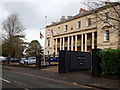
Royal Marines Reserves Bristol Recruitment Centre
At Dorset House on Litfield Place, Clifton. It is a Grade II* listed building and formerly was a pair of villas, erected c1833.
Image: © Eirian Evans
Taken: 4 Mar 2019
0.01 miles
3
Royal Marine Reserves
Clifton, Bristol
Image: © Anthony O'Neil
Taken: 5 Jan 2022
0.02 miles
4
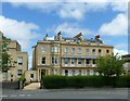
6 & 7 Clifton Down
Originally a pair of house, later a residential care home run by Sisters of the Temple, current status (2017) unknown. Built c.1830 in neoclassical style, possibly by Charles Dyer, with later 19th century alterations, including the canted bay on the left hand house. Listed Grade II.
Image: © Alan Murray-Rust
Taken: 25 Jun 2017
0.02 miles
5
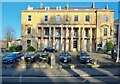
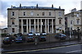
Dorset House, Clifton Down, Bristol
A strange facade, its gangly columns dominating. Pevsner remarked on the "disorderly use indeed of what is not without reason called the orders". R.S. Pope, who did know how to use orders properly, was probably the culprit. Dated 1833-34. Grade II* listed.
Now home to the Royal Marine Reserve and available for hire as a conference venue.
Image: © Stephen Richards
Taken: 23 May 2012
0.03 miles
7
Bristol : Dorset House
Pair of attached houses, now one office. 1829-30. Possibly by RS Pope.
Image: © Lewis Clarke
Taken: 24 Mar 2015
0.03 miles
8
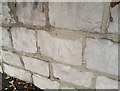
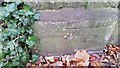
Ordnance Survey Cut Mark
This OS cut mark can be found on the wall of Litfield Place, Clifton Down. It marks a point 90.477m above mean sea level.
Image: © Adrian Dust
Taken: 3 Jan 2020
0.03 miles
9
Ordnance Survey Cut Mark
This OS cut mark can be found on the boundary post of Dorset House. It marks a point 89.300m above mean sea level.
Image: © Adrian Dust
Taken: 17 Dec 2017
0.04 miles
10
Verandah, Clifton Down
Part of the "Full-width Greek Revival-style cast-iron verandah {with} ... stanchions with palmette capitals" on the pair of attached houses described at https://historicengland.org.uk/listing/the-list/list-entry/1202355 and shown in Image
Image: © Derek Harper
Taken: 25 Feb 2019
0.04 miles