IMAGES TAKEN NEAR TO
Canynge Road, BRISTOL, BS8 3LH
Introduction
This page details the photographs taken nearby to Canynge Road, BS8 3LH by members of the Geograph project.
The Geograph project started in 2005 with the aim of publishing, organising and preserving representative images for every square kilometre of Great Britain, Ireland and the Isle of Man.

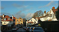
There are currently over 7.5m images from over14,400 individuals and you can help contribute to the project by visiting https://www.geograph.org.uk
Image Map
Images are licensed for reuse under creativecommons.org/licenses/by-sa/2.0
Notes
- Clicking on the map will re-center to the selected point.
- The higher the marker number, the further away the image location is from the centre of the postcode.
Image Listing (309 Images Found)
Images are licensed for reuse under creativecommons.org/licenses/by-sa/2.0
Image
Details
Distance
1
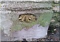
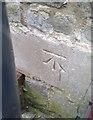
Ordnance Survey Cut Mark
This damaged OS cut mark can be found on the gatepost of No42 Canynge Road. It marks a point 70.836m above mean sea level.
Image: © Adrian Dust
Taken: 2 Jan 2020
0.03 miles
2
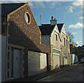
Litfield Road, Clifton
Cottages and their garages on the lane shown in Image
Image: © Derek Harper
Taken: 26 Dec 2021
0.04 miles
3
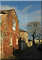
Litfield Road, Clifton
Two cottages by the side of the lane also shown in Image In the background is the tree shown in Image
Image: © Derek Harper
Taken: 26 Dec 2021
0.04 miles
4
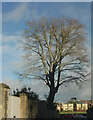
Tree, Litfield Road, Clifton
A copper beech, I think, by the junction with Canynge Road. Across Clifton College New Field are houses on College Fields.
Image: © Derek Harper
Taken: 26 Dec 2021
0.05 miles
5
Norland Road, Clifton
From Camp Road; at the far end is Percival Road.
Image: © Derek Harper
Taken: 26 Dec 2021
0.06 miles
6
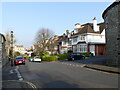
Junction of Camp Road with Percival Road, Clifton, Bristol
Image: © Ruth Sharville
Taken: 23 Mar 2022
0.06 miles
7
Houses, Clifton
By the junction of Percival Road (left) and Camp Road.
Image: © Derek Harper
Taken: 26 Dec 2021
0.06 miles
8
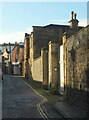
Litfield Road, Clifton
The curving urban lane links Canynge Road to Percival Road, passing several cottages.
Image: © Derek Harper
Taken: 26 Dec 2021
0.07 miles
9
Ordnance Survey Cut Mark
This OS cut mark can be found on Camp House Cottage, Camp Road. It marks a point 77.508m above mean sea level.
Image: © Adrian Dust
Taken: 2 Jan 2020
0.07 miles
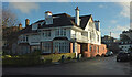
10
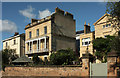
Houses on Canynge Square, Clifton
The rears, seen from Canynge Road. Most of the houses on the square are listed; left of centre is number 36 "1848. By Charles Underwood .. The ashlar garden front {has} a first-floor full-width tented balcony with cast-iron brackets, bowed railings, and stanchions and top rail pierced by round holes" https://www.historicengland.org.uk/listing/the-list/list-entry/1204959 . The gable on the right belongs to number 37, also by Charles Underwood https://www.historicengland.org.uk/listing/the-list/list-entry/1202049 . The listing also includes the "sandstone garden walls, and a pair of capped piers" in the foreground.. On the left are numbers 34 and 35 https://www.historicengland.org.uk/listing/the-list/list-entry/1202048 .
Image: © Derek Harper
Taken: 13 Sep 2018
0.07 miles