IMAGES TAKEN NEAR TO
Canynge Road, BRISTOL, BS8 3JX
Introduction
This page details the photographs taken nearby to Canynge Road, BS8 3JX by members of the Geograph project.
The Geograph project started in 2005 with the aim of publishing, organising and preserving representative images for every square kilometre of Great Britain, Ireland and the Isle of Man.

There are currently over 7.5m images from over14,400 individuals and you can help contribute to the project by visiting https://www.geograph.org.uk
Image Map
Images are licensed for reuse under creativecommons.org/licenses/by-sa/2.0
Notes
- Clicking on the map will re-center to the selected point.
- The higher the marker number, the further away the image location is from the centre of the postcode.
Image Listing (465 Images Found)
Images are licensed for reuse under creativecommons.org/licenses/by-sa/2.0
Image
Details
Distance
1

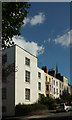
Canynge Road, Clifton
A listed terrace dating from about 1840. "Late Georgian style. Each of 3 storeys and basement; 2-window range. A terrace of varying widths with coped parapets, No.6 extended with a full attic storey" https://www.historicengland.org.uk/listing/the-list/list-entry/1204769 .
Image: © Derek Harper
Taken: 13 Sep 2018
0.01 miles
2
Canynge Road, Clifton
A reverse view of Image] https://www.historicengland.org.uk/listing/the-list/list-entry/1204769 with a more modern building in the foreground.
Image: © Derek Harper
Taken: 13 Sep 2018
0.02 miles
3
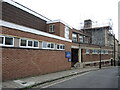
Swimming Pool, Climbing Wall and Gym
And a health and fitness suite too! Quite a facility at Clifton High School.
Image: © Neil Owen
Taken: 1 Jul 2021
0.03 miles
4
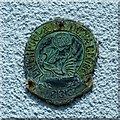
Firemark, Penrose Cottage, Clifton
Inscribed 'Liverpool, London & Globe 1836'. See http://www.geograph.org.uk/photo/5445807 for location.
Image: © Alan Murray-Rust
Taken: 25 Jun 2017
0.03 miles
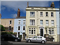
5
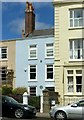
Penrose Cottage, Clifton Down
One of a pair of houses built c.1780. The 'blue' (actually green) plaque commemorates the poet Walter Savage Landor. There is a firemark http://www.geograph.org.uk/photo/5445804 between the upper storey windows. Listed Grade II in combination with its neighbour to the left.
Image: © Alan Murray-Rust
Taken: 25 Jun 2017
0.03 miles
6
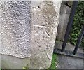
Ordnance Survey Cut Mark
This OS cut mark can be found on Harley Lodge, Canynge Road. It marks a point 81.525m above mean sea level.
Image: © Adrian Dust
Taken: 2 Jan 2020
0.03 miles
7
Penrose Cottage
The unusually small blue town house left of centre bears a fire insurance plaque and a grey plaque informing the observer that the poet and writer Walter Savage Landor (1775-1864) lived there for a short time in the 1830s.
Image: © Anne Burgess
Taken: 25 Jun 2017
0.04 miles
8
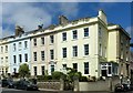
Georgian houses on Clifton Down
Dating from c.1760, these four houses form a single group Listed Grade II. The end house (Glendower House) has two commemorative plaques recalling former inhabitants Sir Archibald Russell (Chief Engineer BAC Filton, with work on the Brabazon, Britannia and Concorde aircraft) and Sir Fabian Ware (Founder of the Imperial War Graves Commission).
Image: © Alan Murray-Rust
Taken: 25 Jun 2017
0.04 miles
9
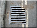
Local iron for local sewers
A drain grating bears the city name.
Image: © Neil Owen
Taken: 1 Jul 2021
0.04 miles
10
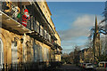
Harley Place, Clifton
The grade II* listed terrace is described at https://historicengland.org.uk/listing/the-list/list-entry/1205767?section=official-listing , and is seen from a wide raised pavement in front of it. The "wrought-iron spear-headed basement area railings" form part of the listing. On the right is Christ Church, also grade II* listed https://historicengland.org.uk/listing/the-list/list-entry/1202095?section=official-listing . Santa makes his presence felt, it being Christmas, or, at least, the day after.
Image: © Derek Harper
Taken: 26 Dec 2021
0.04 miles