IMAGES TAKEN NEAR TO
Codrington Place, BRISTOL, BS8 3DE
Introduction
This page details the photographs taken nearby to Codrington Place, BS8 3DE by members of the Geograph project.
The Geograph project started in 2005 with the aim of publishing, organising and preserving representative images for every square kilometre of Great Britain, Ireland and the Isle of Man.

There are currently over 7.5m images from over14,400 individuals and you can help contribute to the project by visiting https://www.geograph.org.uk
Image Map
Images are licensed for reuse under creativecommons.org/licenses/by-sa/2.0
Notes
- Clicking on the map will re-center to the selected point.
- The higher the marker number, the further away the image location is from the centre of the postcode.
Image Listing (460 Images Found)
Images are licensed for reuse under creativecommons.org/licenses/by-sa/2.0
Image
Details
Distance
1
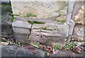
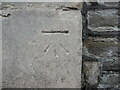
Ordnance Survey Cut Mark
This OS cut mark can be found on the gatepost of No4 Belgrave Place. It marks a point 67.471m above mean sea level.
Image: © Adrian Dust
Taken: 2 Jan 2020
0.02 miles
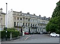
2
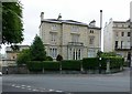
Vyvyan House, Clifton Park
Later than most of the surrounding houses, dated c.1860, in Italianate style. Listed Grade II.
Image: © Alan Murray-Rust
Taken: 24 Jun 2017
0.03 miles
3
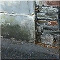
Bench mark, Dyrham Court, Clifton Park
See http://www.geograph.org.uk/photo/5444322 for location.
Image: © Alan Murray-Rust
Taken: 24 Jun 2017
0.03 miles
4
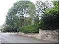
Looking up Clifton Park
On the right is a benchmark - see Image
Image: © Neil Owen
Taken: 2 Aug 2021
0.03 miles
5
Benchmark on Clifton Park
On a stone pier is a cutmark, dating from the development of the area in the 1800s. See https://www.bench-marks.org.uk/bm86228 for the entry in the Benchmark Database and Image] for a wider view.
Image: © Neil Owen
Taken: 2 Aug 2021
0.03 miles
6
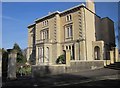
Vyvyan House, Bristol
A typically grand Clifton house, built in about 1860 http://list.historicengland.org.uk/resultsingle.aspx?uid=1202114&searchtype=mapsearch . Also listed are the "front garden piers, and gate piers". The house is now divided into flats.
Image: © Derek Harper
Taken: 22 Mar 2015
0.03 miles
7
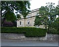
Dyrham Court, Clifton Park
There is a bench mark http://www.geograph.org.uk/photo/5444321 on the pillar centre-right of picture.
Image: © Alan Murray-Rust
Taken: 24 Jun 2017
0.03 miles
8
Dyrham Court, Clifton Park
One of a small number of detached houses in the immediate neighbourhood. Designed c.1850 by Charles Underwood, now converted to offices. Limestone ashlar in neo-classical style. Listed Grade II
Image: © Alan Murray-Rust
Taken: 24 Jun 2017
0.04 miles
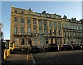
9
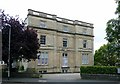
Vyvyan Terrace, Clifton Park
Terrace, probably by R S Pope between 1832 and 1846, 19 houses, the end blocks of three projecting slightly forward with two-storey colonnade/pilasters. Limestone ashlar, neoclassical style, Listed Grade II*.
Named after Sir Richard Vyvyan, MP for Bristol 1832-7, referred to in the listing description as 'infamous' although nothing in his Wikipedia biography https://en.wikipedia.org/wiki/Sir_Richard_Vyvyan,_8th_Baronet supports this.
Image: © Alan Murray-Rust
Taken: 24 Jun 2017
0.04 miles
10
Vyvyan Terrace, Clifton
The eastern end of the grade II* listed terrace described at https://www.historicengland.org.uk/listing/the-list/list-entry/1202664 : "Terrace of 19 houses. 1832-46. Probably by RS Pope ... One of the finest of the Regency Clifton terraces, named after the infamous Tory MP Sir Richard Vyvyan".
Image: © Derek Harper
Taken: 27 Oct 2017
0.04 miles