IMAGES TAKEN NEAR TO
Kensington Place, BRISTOL, BS8 3AH
Introduction
This page details the photographs taken nearby to Kensington Place, BS8 3AH by members of the Geograph project.
The Geograph project started in 2005 with the aim of publishing, organising and preserving representative images for every square kilometre of Great Britain, Ireland and the Isle of Man.

There are currently over 7.5m images from over14,400 individuals and you can help contribute to the project by visiting https://www.geograph.org.uk
Image Map
Images are licensed for reuse under creativecommons.org/licenses/by-sa/2.0
Notes
- Clicking on the map will re-center to the selected point.
- The higher the marker number, the further away the image location is from the centre of the postcode.
Image Listing (545 Images Found)
Images are licensed for reuse under creativecommons.org/licenses/by-sa/2.0
Image
Details
Distance
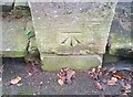
1

Bench mark, 2 Kensington Place, Clifton
See http://www.geograph.org.uk/photo/5444499 for location.
Image: © Alan Murray-Rust
Taken: 24 Jun 2017
0.01 miles
2
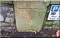
Ordnance Survey Cut Mark
This OS cut mark can be found on wall of No2 Kensington Place. It marks a point 72.091m above mean sea level.
Image: © Adrian Dust
Taken: 2 Jan 2020
0.01 miles
3
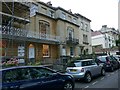
Kensington Place, Clifton
A terrace of 4 houses by Charles Underwood, 1842, limestone ashlar, Listed Grade II. (The end house is not part of the group.)
There is a bench mark http://www.geograph.org.uk/photo/5444497 on the gatepost just to the left of the grey car.
Image: © Alan Murray-Rust
Taken: 24 Jun 2017
0.02 miles
4
Bench mark, 11 Richmond Park Road
See http://www.geograph.org.uk/photo/5444503 for location.
Image: © Alan Murray-Rust
Taken: 24 Jun 2017
0.04 miles
5
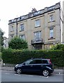
9 & 11 Richmond Park Road
Pair of attached houses, c.1850, limestone ashlar in neoclassical style, Listed Grade II.
There is a bench mark http://www.geograph.org.uk/photo/5444500 on the gatepost at the extreme left.
Image: © Alan Murray-Rust
Taken: 24 Jun 2017
0.04 miles
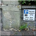
6
Ordnance Survey Cut Mark
This OS cut mark can be found on the wall of No11 Richmond Park Road. It marks a point 68.857m above mean sea level.
Image: © Adrian Dust
Taken: 2 Jan 2020
0.04 miles
7
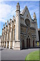
Buckingham Chapel, Bristol
Buckingham Chapel on Queens Road in Bristol. This Baptist chapel was built in 1842 and designed by Richard Shackleton Pope; it is an example of Gothic Revival architecture. The chapel is a Grade II listed building.
Image: © Philip Halling
Taken: 18 Aug 2013
0.05 miles
8
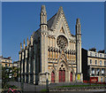
Buckingham Baptist Chapel, Queen's Road, Bristol
Very ornate "French-influenced Gothic". The splendid rose window is a "sham", i.e. purely for show. By R.S. Pope, 1842-47, who might have been a non-conformist as he donated his fee. Grade II* listed.
Image: © Stephen Richards
Taken: 23 May 2012
0.05 miles
9
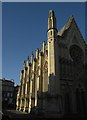
Buckingham Chapel, Clifton
The grade II* listed baptist chapel is also shown at http://www.geograph.org.uk/search.php?i=78620982 and described at https://www.historicengland.org.uk/listing/the-list/list-entry/1218249 .
Image: © Derek Harper
Taken: 27 Oct 2017
0.05 miles
10
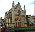
Buckingham Chapel, Clifton, Bristol
Viewed across Queen's Road. The nameboard shows Buckingham Chapel FREE EVANGELICAL BAPTIST. http://www.geograph.org.uk/photo/2497334 to another view and some details.
Image: © Jaggery
Taken: 7 May 2012
0.05 miles