IMAGES TAKEN NEAR TO
Richmond Dale, BRISTOL, BS8 2UB
Introduction
This page details the photographs taken nearby to Richmond Dale, BS8 2UB by members of the Geograph project.
The Geograph project started in 2005 with the aim of publishing, organising and preserving representative images for every square kilometre of Great Britain, Ireland and the Isle of Man.

There are currently over 7.5m images from over14,400 individuals and you can help contribute to the project by visiting https://www.geograph.org.uk
Image Map
Images are licensed for reuse under creativecommons.org/licenses/by-sa/2.0
Notes
- Clicking on the map will re-center to the selected point.
- The higher the marker number, the further away the image location is from the centre of the postcode.
Image Listing (278 Images Found)
Images are licensed for reuse under creativecommons.org/licenses/by-sa/2.0
Image
Details
Distance
1
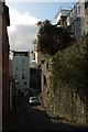
Belgrave Hill, Clifton
With the retaining wall shown in Image] on the right. On the immediate left is a listed brick former mission house and reading room.
Image: © Derek Harper
Taken: 29 Oct 2017
0.01 miles
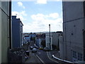
2
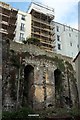
Retaining wall and arches, Belgrave Hill, Clifton
From Quarry Road, which turns right along Belgrave Hill beneath the arches. The buildings above front onto Upper Belgrave Road.
Image: © Derek Harper
Taken: 29 Oct 2017
0.02 miles
4
Sutherland Place, Clifton
A terrace drops steeply down from Upper Belgrave Road.
Image: © Derek Harper
Taken: 29 Oct 2017
0.03 miles
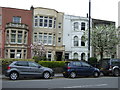
5
Side street in Clifton, Bristol
Even the side streets are packed with redolence, history and character.
Image: © Jeremy Bolwell
Taken: 9 May 2015
0.04 miles
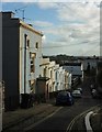
6
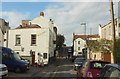
High Street, Clifton
A modest little urban lane, and some way from the heart of Clifton village. On the left is the Beaufort Arms Image
Image: © Derek Harper
Taken: 29 Oct 2017
0.04 miles
7
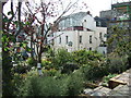
The Easter Garden, Bristol
The Easter Garden occupies a small patch of former wasteland either side of a public right of way just off the top of Whiteladies Road, between the Port of Call and Beaufort Arms public houses. Derelict for many years, a local community group in the 1990s turned it into the horticultural haven it is today. However, they have to constantly fight for its survival against potential developers.
Image: © C P Smith
Taken: 1 Sep 2010
0.04 miles
8
Port of Call, Bristol
Established in 1788, http://www.geograph.org.uk/photo/2935972 the pub is on York Street, a short (40 metres) and narrow street between Wesley Place on the camera side, and Whiteladies Road.
The contours along York Street are similar to those along a steep humpback bridge.
Image: © Jaggery
Taken: 7 May 2012
0.04 miles
9
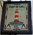
Port of Call pub sign, Bristol
The sign hangs from a frame on the wall of this pub. http://www.geograph.org.uk/photo/2935969
Image: © Jaggery
Taken: 7 May 2012
0.04 miles
10
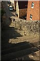
Quarry Steps, Clifton
As Image, the name applies to the street beyond as well as these steps.
Image: © Derek Harper
Taken: 29 Oct 2017
0.04 miles