IMAGES TAKEN NEAR TO
Downfield Road, BRISTOL, BS8 2TQ
Introduction
This page details the photographs taken nearby to Downfield Road, BS8 2TQ by members of the Geograph project.
The Geograph project started in 2005 with the aim of publishing, organising and preserving representative images for every square kilometre of Great Britain, Ireland and the Isle of Man.

There are currently over 7.5m images from over14,400 individuals and you can help contribute to the project by visiting https://www.geograph.org.uk
Image Map
Images are licensed for reuse under creativecommons.org/licenses/by-sa/2.0
Notes
- Clicking on the map will re-center to the selected point.
- The higher the marker number, the further away the image location is from the centre of the postcode.
Image Listing (252 Images Found)
Images are licensed for reuse under creativecommons.org/licenses/by-sa/2.0
Image
Details
Distance
1
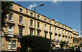
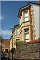
Terrace on Apsley Road, Clifton
A listed terrace of eight; the last two properties on the right have "the upper floors set back behind an open arcade, possibly planned as the centre of a wider terrace" https://www.historicengland.org.uk/listing/the-list/list-entry/1201958 . "c1840. Possibly by RS Pope ... Late Georgian style". Part of the terrace is shown from the other direction in Image
Image: © Derek Harper
Taken: 11 Jul 2018
0.03 miles
2
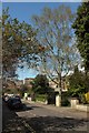
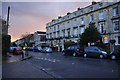
Downfield Road, Bristol
A curious course for this residential road in Clifton; this is reach two of four, each of them separated by right-angled bends.
Image: © Derek Harper
Taken: 18 Apr 2016
0.04 miles
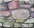
3

Ordnance Survey Cut Mark
This OS cut mark can be found on gatepost of No26 Apsley Road. It marks a point 72.850m above mean sea level.
Image: © Adrian Dust
Taken: 2 Jan 2020
0.04 miles
4
Downfield Road, Bristol
The westernmost stretch of the road, which negotiates three right-angled bends. This is taken from one of them, the same one as Image
Image: © Derek Harper
Taken: 18 Apr 2016
0.05 miles
5
Ordnance Survey Cut Mark
This OS cut mark can be found on the wall SE end of Downfield Road. It marks a point 77.285m above mean sea level.
Image: © Adrian Dust
Taken: 2 Jan 2020
0.05 miles
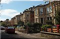
6
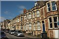
Downfield Road, Bristol
Canted bays on the eastern cul-de-sac of the road.
Image: © Derek Harper
Taken: 18 Apr 2016
0.06 miles
7
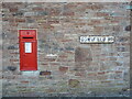
Postbox on Downfield Road
A Victorian one at that. This end of the road was not built until the very late 1800s, in contrast to most of the rest which are earlier.
Image: © Neil Owen
Taken: 22 Mar 2022
0.06 miles
8
Bristol : Apsley Road
A small residential road seen from the junction with St John's Road.
Image: © Lewis Clarke
Taken: 24 Mar 2015
0.07 miles
9
Normanton Road, Bristol
A terrace on the northeast side of the street. On the right is a no through road sign indicating the cul-de-sac shown in Image
Image: © Derek Harper
Taken: 18 Apr 2016
0.08 miles
10
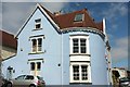
House on Anglesea Place, Bristol
This attractive house is on the corner of Wellington Park.
Image: © Derek Harper
Taken: 18 Apr 2016
0.08 miles