IMAGES TAKEN NEAR TO
Downfield Road, BRISTOL, BS8 2TJ
Introduction
This page details the photographs taken nearby to Downfield Road, BS8 2TJ by members of the Geograph project.
The Geograph project started in 2005 with the aim of publishing, organising and preserving representative images for every square kilometre of Great Britain, Ireland and the Isle of Man.

There are currently over 7.5m images from over14,400 individuals and you can help contribute to the project by visiting https://www.geograph.org.uk
Image Map
Images are licensed for reuse under creativecommons.org/licenses/by-sa/2.0
Notes
- Clicking on the map will re-center to the selected point.
- The higher the marker number, the further away the image location is from the centre of the postcode.
Image Listing (263 Images Found)
Images are licensed for reuse under creativecommons.org/licenses/by-sa/2.0
Image
Details
Distance
1
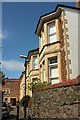
Downfield Road, Bristol
Canted bays on the eastern cul-de-sac of the road.
Image: © Derek Harper
Taken: 18 Apr 2016
0.01 miles
2
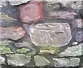
Ordnance Survey Cut Mark
This OS cut mark can be found on the wall SE end of Downfield Road. It marks a point 77.285m above mean sea level.
Image: © Adrian Dust
Taken: 2 Jan 2020
0.01 miles
3
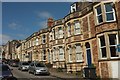
Normanton Road, Bristol
A terrace on the northeast side of the street. On the right is a no through road sign indicating the cul-de-sac shown in Image
Image: © Derek Harper
Taken: 18 Apr 2016
0.03 miles
4
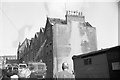
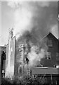
Anglesea Place fire - looking north (1965)
On a sunny Sunday morning in March 1965 a serious fire with tragic consequences broke out in the house on Anglesea Place at the corner with Mornington Road. This is looking north towards Worrall Road. On the left in the distance the rear elevations of houses in Upper Belgrave Road are visible.
Image: © Martin Tester
Taken: 28 Mar 1965
0.04 miles
5
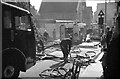
Anglesea Place fire - rear view (1965)
On a sunny Sunday morning in March 1965 a serious fire with tragic consequences broke out in the house on Anglesea Place at the corner with Mornington Road. This is the view from Mornington Road of the rear of the property
Image: © Martin Tester
Taken: 28 Mar 1965
0.04 miles
6
Houses on Anglesea Place, Bristol
Gable ends on the stretch between Mornington Road and Wellington Park.
Image: © Derek Harper
Taken: 18 Apr 2016
0.04 miles
7
Anglesea Place fire - looking south (1965)
On a sunny Sunday morning in March 1965 a serious fire with tragic consequences broke out in the house on Anglesea Place at the corner with Mornington Road. This is looking south towards Wellington Park. For a photo taken from almost the same spot in 2016 see Image
Image: © Martin Tester
Taken: 28 Mar 1965
0.04 miles
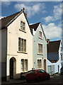
8
House on Anglesea Place, Bristol
This attractive house is on the corner of Wellington Park.
Image: © Derek Harper
Taken: 18 Apr 2016
0.04 miles
9
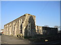
Part of the old school
Worrall Road has been home to the St John's C of E primary school for generations. Some of the older buildings seem to be left unoccupied and as a shell. The modern school buildings are much more recent and are just behind the walls, replacing a terrace of houses known as Highland Place. See Image] for a benchmark on the remaining edifice.
Image: © Neil Owen
Taken: 22 Mar 2022
0.05 miles
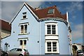
10
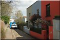
Mornington Road, Bristol
With some attractive houses at the opposite end to the one shown in Image But I really need to be here late on a summer's day.
Image: © Derek Harper
Taken: 18 Apr 2016
0.05 miles