IMAGES TAKEN NEAR TO
Apsley Road, BRISTOL, BS8 2SW
Introduction
This page details the photographs taken nearby to Apsley Road, BS8 2SW by members of the Geograph project.
The Geograph project started in 2005 with the aim of publishing, organising and preserving representative images for every square kilometre of Great Britain, Ireland and the Isle of Man.

There are currently over 7.5m images from over14,400 individuals and you can help contribute to the project by visiting https://www.geograph.org.uk
Image Map
Images are licensed for reuse under creativecommons.org/licenses/by-sa/2.0
Notes
- Clicking on the map will re-center to the selected point.
- The higher the marker number, the further away the image location is from the centre of the postcode.
Image Listing (276 Images Found)
Images are licensed for reuse under creativecommons.org/licenses/by-sa/2.0
Image
Details
Distance
1
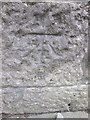
Ordnance Survey Cut Mark
This OS cut mark can be found on the NW face of St John's Church on Apsley Road. It marks a point 74.170m above mean sea level.
Image: © Adrian Dust
Taken: 5 Mar 2016
0.02 miles
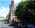
2
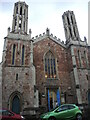
North entrance to the old St John the Evangelist church
The church was sold off in 1984 and has had a few different commercial uses since; presently it is a day nursery and pre-school. Note the large embattlements that mark this old church out.
Image: © Neil Owen
Taken: 2 Aug 2021
0.02 miles
3
Bristol : Apsley Road
A small residential road heading through the Clifton area.
Image: © Lewis Clarke
Taken: 24 Mar 2015
0.02 miles
4
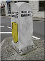
Drip Fed Empire?
Bristol is full of little bits of oddity. Even if it does seem to spell Emrire...
Image: © Neil Owen
Taken: 7 Sep 2017
0.02 miles
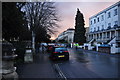
5
Whiteladies Road
Approaching the steep ascent of Black Boy Hill. On the left is Apsley Road.
Image: © Derek Harper
Taken: 6 Nov 2015
0.02 miles
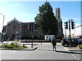
6
Whiteladies Road, Northern End - BS8
This decommissioned church at the Apsley Road/Whiteladies Road junction is now called St John's Court and houses a number of apartments plus the premises of the Bristol Auction Rooms. Burlington Road begins and/or ends on the other side of Whiteladies Road.
Image: © David Hallam-Jones
Taken: 31 Jul 2012
0.02 miles
7
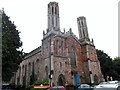
St John's Church, Apsley Road
On the corner of Apsley Road and Whiteladies Road, stands the distinctive church of St John the Evangelist. The church is cruciform and orientated in reality north to south. It was designed by S.J.Hicks and built in 1841. It was enlarged by S.B.Gabriel in 1864 when the chancel was added. By 1984 it had closed and was used for a while by a local theatre group. The interior was subdivided in 1990 to create the Bristol Auction Rooms on the ground floor and a media production company in the upper part and in 2013 it was converted further and is now Mama Bear's Day Nursery.
Image: © Eirian Evans
Taken: 15 Oct 2014
0.02 miles
8
Imposing Nursery
This building became a day nursery in 2013 when the former Bristol Auction Rooms was converted. Before being the Auction Rooms it was the Church of St John with St Anslem.
Image: © Steve Barnes
Taken: 3 Oct 2016
0.02 miles
9
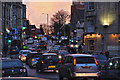
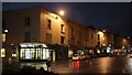
Bristol : Whiteladies Road
Looking along Whiteladies Road during the evening.
Image: © Lewis Clarke
Taken: 24 Mar 2015
0.02 miles
10
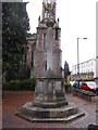
War Memorial, Whiteladies Road
On the corner of Apsley Road and Whiteladies Road, near the former St John's Church.
Image: © Eirian Evans
Taken: 15 Oct 2014
0.02 miles