IMAGES TAKEN NEAR TO
Apsley Road, BRISTOL, BS8 2ST
Introduction
This page details the photographs taken nearby to Apsley Road, BS8 2ST by members of the Geograph project.
The Geograph project started in 2005 with the aim of publishing, organising and preserving representative images for every square kilometre of Great Britain, Ireland and the Isle of Man.

There are currently over 7.5m images from over14,400 individuals and you can help contribute to the project by visiting https://www.geograph.org.uk
Image Map
Images are licensed for reuse under creativecommons.org/licenses/by-sa/2.0
Notes
- Clicking on the map will re-center to the selected point.
- The higher the marker number, the further away the image location is from the centre of the postcode.
Image Listing (298 Images Found)
Images are licensed for reuse under creativecommons.org/licenses/by-sa/2.0
Image
Details
Distance
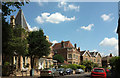
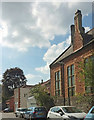
1
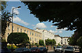
Apsley Road, Clifton
The listed early Victorian terrace shown in Image] is succeeded by two later terraces, Old Vicarage Place and Aspley Mews.
Image: © Derek Harper
Taken: 11 Jul 2018
0.02 miles
2
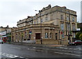
Lloyds TSB Redland Bristol branch
Bank branch at 163 Whiteladies Road, on the corner of Burlington Road.
Image: © Jaggery
Taken: 7 May 2012
0.03 miles
3
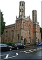
Former Church of St John the Evangelist, Bristol
Located on the corner of Apsley Road and Whiteladies Road.
The distinctive church was built in 1841, enlarged in 1864.
It closed as a church in the early 1980s.
It is currently (May 2012) the premises of Dreweatts Bristol, auctioneers.
Image: © Jaggery
Taken: 7 May 2012
0.03 miles
4
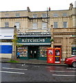
Kitchens, Whiteladies Road, Bristol
Cookware retailers at 167 Whiteladies Road.
There is ornate white-painted metalwork above the doorway at first-floor level.
Two distinctive phoneboxes are on the pavement between Kitchens
and a branch of Lloyds TSB. http://www.geograph.org.uk/photo/2935767
Image: © Jaggery
Taken: 7 May 2012
0.03 miles
5

Ordnance Survey Cut Mark
This OS cut mark can be found on the wall of No49 Apsley Road. It marks a point 74.204m above mean sea level.
Image: © Adrian Dust
Taken: 2 Jan 2020
0.03 miles
6
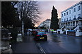
Bristol : Apsley Road
A small residential road heading through the Clifton area.
Image: © Lewis Clarke
Taken: 24 Mar 2015
0.03 miles
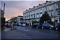
7
Hurle Crescent, Clifton
Seen from the junction with St John's Road. On the left is the property shown in Image
Image: © Derek Harper
Taken: 11 Jul 2018
0.03 miles
8
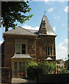
House on St John's Road, Clifton
A distinctive property on the corner of Hurle Crescent.
Image: © Derek Harper
Taken: 11 Jul 2018
0.03 miles
9
Bristol : Apsley Road
A small residential road seen from the junction with St John's Road.
Image: © Lewis Clarke
Taken: 24 Mar 2015
0.04 miles
10
King's Parade Mews, Bristol
Seen from Whiteladies Road. On the right is the side wall of River Cottage Kitchen.
Image: © Derek Harper
Taken: 8 Sep 2019
0.04 miles