IMAGES TAKEN NEAR TO
Apsley Road, BRISTOL, BS8 2SS
Introduction
This page details the photographs taken nearby to Apsley Road, BS8 2SS by members of the Geograph project.
The Geograph project started in 2005 with the aim of publishing, organising and preserving representative images for every square kilometre of Great Britain, Ireland and the Isle of Man.

There are currently over 7.5m images from over14,400 individuals and you can help contribute to the project by visiting https://www.geograph.org.uk
Image Map
Images are licensed for reuse under creativecommons.org/licenses/by-sa/2.0
Notes
- Clicking on the map will re-center to the selected point.
- The higher the marker number, the further away the image location is from the centre of the postcode.
Image Listing (291 Images Found)
Images are licensed for reuse under creativecommons.org/licenses/by-sa/2.0
Image
Details
Distance
1

Ordnance Survey Cut Mark
This OS cut mark can be found on gatepost of No26 Apsley Road. It marks a point 72.850m above mean sea level.
Image: © Adrian Dust
Taken: 2 Jan 2020
0.03 miles
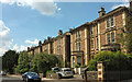
2
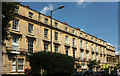
Terrace on Apsley Road, Clifton
A listed terrace of eight; the last two properties on the right have "the upper floors set back behind an open arcade, possibly planned as the centre of a wider terrace" https://www.historicengland.org.uk/listing/the-list/list-entry/1201958 . "c1840. Possibly by RS Pope ... Late Georgian style". Part of the terrace is shown from the other direction in Image
Image: © Derek Harper
Taken: 11 Jul 2018
0.03 miles
3
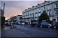
Beaufort Road, Clifton
The northeastern end of the road, meeting St John's Road.
Image: © Derek Harper
Taken: 26 Dec 2021
0.04 miles
4
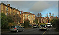
Bristol : Apsley Road
A small residential road seen from the junction with St John's Road.
Image: © Lewis Clarke
Taken: 24 Mar 2015
0.04 miles
5
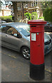
Postbox, St John's Road, Clifton
An anonymous Victorian postbox, number BS8 386. See Image The pale sunlit house on the left is on Hurle Crescent.
Image: © Derek Harper
Taken: 11 Jul 2018
0.04 miles
6
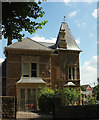
House on St John's Road, Clifton
A distinctive property on the corner of Hurle Crescent.
Image: © Derek Harper
Taken: 11 Jul 2018
0.04 miles
7
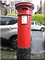
An uncrowned letterbox
One of Handysides' work without a cypher.
Image: © Neil Owen
Taken: 2 Aug 2021
0.04 miles
8
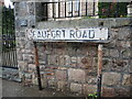
Beaufort Road sign
A Bristol 8 suburb sign, looking every year its age.
Image: © Neil Owen
Taken: 2 Aug 2021
0.05 miles
9
Beaufort Road, Clifton
Houses on the north side of the road.
Image: © Derek Harper
Taken: 11 Jul 2018
0.05 miles
10

Ordnance Survey Cut Mark
This OS cut mark can be found on the wall of No49 Apsley Road. It marks a point 74.204m above mean sea level.
Image: © Adrian Dust
Taken: 2 Jan 2020
0.05 miles