IMAGES TAKEN NEAR TO
Woodbury Lane, BRISTOL, BS8 2SA
Introduction
This page details the photographs taken nearby to Woodbury Lane, BS8 2SA by members of the Geograph project.
The Geograph project started in 2005 with the aim of publishing, organising and preserving representative images for every square kilometre of Great Britain, Ireland and the Isle of Man.

There are currently over 7.5m images from over14,400 individuals and you can help contribute to the project by visiting https://www.geograph.org.uk
Image Map
Images are licensed for reuse under creativecommons.org/licenses/by-sa/2.0
Notes
- Clicking on the map will re-center to the selected point.
- The higher the marker number, the further away the image location is from the centre of the postcode.
Image Listing (290 Images Found)
Images are licensed for reuse under creativecommons.org/licenses/by-sa/2.0
Image
Details
Distance
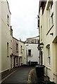
1
Woodbury Lane
A curious collection of houses in an older part of Blackboy Hill.
Image: © Neil Owen
Taken: 2 Aug 2021
0.01 miles
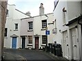
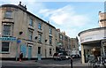
2
Woodbury Lane, Bristol
A little cul-de-sac bends to meet Whiteladies Road.
Image: © Derek Harper
Taken: 5 Jun 2017
0.01 miles
3
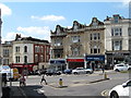
Grove Road, Bristol
Seen across Whiteladies Road (the A4018) below Black Boy Hill. The seven C18 houses after the Victorian corner building on the right are listed: https://www.historicengland.org.uk/listing/the-list/list-entry/1202254 ; https://www.historicengland.org.uk/listing/the-list/list-entry/1207519 and https://www.historicengland.org.uk/listing/the-list/list-entry/1282281 .
Image: © Derek Harper
Taken: 29 Oct 2017
0.02 miles
4
Redland Terrace, Redland
Seen from its junction with Lower Redland Road.
Image: © Derek Harper
Taken: 25 Jun 2015
0.03 miles
5
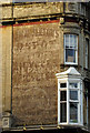
Signs of a Past Life
The side of this building obviously used to be used to display advertisements mostly relating to cycling and also I can make out an Ironmonger.
Image: © Linda Bailey
Taken: 20 Nov 2006
0.03 miles
6
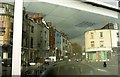
Reflection of Grove Road, Bristol
In a vacant shop window on the west side of Whiteladies Road. The real thing is at Image
Image: © Derek Harper
Taken: 29 Oct 2017
0.03 miles
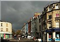
7
Blackboy Hill
The short stretch between the upper end of Whiteladies Road and the downs is known as Blackboy Hill which is lined with local shops and businesses. Somewhere in the shadows on the left there was once the Chiquita Restaurant where hungry students from nearby Redland College would appear when unable to face the fare on offer at their nearby college refectory.
Image: © Gordon Hatton
Taken: 24 May 2017
0.03 miles
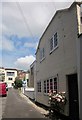
8
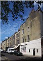
Wild Oats, Lower Redland Rd, Bristol
A natural foods shop occupies the east end of this terrace, the other end of which reaches Whiteladies Road at the Blackboy Inn.
Image: © Derek Harper
Taken: 25 Jun 2015
0.04 miles
10
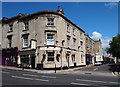
Whiteladies Road, Northern End, BS8
This is The Black Boy pub on the corner plot where Lower Redland Road joins and/or leaves Whiteladies Road. The myth that this pub was associated with the presence of a substantial number of young African slaves in this area, albeit Bristol's appalling record in slave trading, has by now almost been laid to rest. It seems that in the early 18th century there was an inn hereabouts that stood on an island of land in the middle of this main thoroughfare, a hostelry called The Blackamoor's Head Inn. However, by 1803 it had become known as The Blackboy Tavern. It seems that these premises were demolished in 1874 to allow for changes to the road, since up until this time the pub had straddled the road, thereby forcing traffic to pass round it. But how the inn got its original name and its subsequent names appears to remain the subject of debate.
Image: © David Hallam-Jones
Taken: 31 Jul 2012
0.04 miles