IMAGES TAKEN NEAR TO
Whiteladies Road, BRISTOL, BS8 2LY
Introduction
This page details the photographs taken nearby to Whiteladies Road, BS8 2LY by members of the Geograph project.
The Geograph project started in 2005 with the aim of publishing, organising and preserving representative images for every square kilometre of Great Britain, Ireland and the Isle of Man.

There are currently over 7.5m images from over14,400 individuals and you can help contribute to the project by visiting https://www.geograph.org.uk
Image Map
Images are licensed for reuse under creativecommons.org/licenses/by-sa/2.0
Notes
- Clicking on the map will re-center to the selected point.
- The higher the marker number, the further away the image location is from the centre of the postcode.
Image Listing (329 Images Found)
Images are licensed for reuse under creativecommons.org/licenses/by-sa/2.0
Image
Details
Distance
1
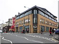
Office building, on Whiteladies Road
Image: © Roger Cornfoot
Taken: 18 Feb 2011
0.01 miles
2
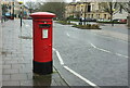
Postbox, Whiteladies Road
Elizabeth II postbox BS8 388 is close to a pedestrian crossing on the A4018 near the junction with West Park.
Image: © Derek Harper
Taken: 5 Mar 2020
0.02 miles
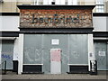
3

Letterbox on a diet
This one on Whiteladies Road doesn't seem to be that hungry for customers. A plate has been bolted over the original aperture and will only accept thin letters now.
Image: © Neil Owen
Taken: 2 Aug 2021
0.02 miles
4
be.in:bristol
But make sure you come when it's open.
Image: © Neil Owen
Taken: 2 Aug 2021
0.02 miles
5
The Vittoria
On Whiteladies Road, it advertises itself above the entrance as a pub and kitchen.
The weeks ales included Tribute - St Austell, Bombardier - Wells, Bob - Wickwar - Classic Amber Ale.
Image: © Richard Hoare
Taken: 25 Jun 2017
0.03 miles
6
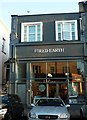
Fired Earth, Whiteladies Road
Its shopfront reflecting the building opposite, across Aberdeen Road.
Image: © Derek Harper
Taken: 27 Oct 2017
0.03 miles
7
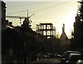
Tempus resurget
Looking along Aberdeen Road to the Galliard Tempus "boutique" development site on Whiteladies Road, silhouetted against the western sky, with Clifton Cathedral and the spire of St Paul's church beyond.
Image: © Derek Harper
Taken: 27 Oct 2017
0.03 miles
8
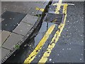
Cast Iron Kerb, Clifton, Bristol
These serrated cast iron kerbs are a frequent feature on the old Bristol pavements. They are usually found at the street corners which would have had the greatest amounts of wear and impact. Very few other cities used them.This is on the corner of Aberdeen Rd and Whiteladies Rd.
Image: © Nigel Mykura
Taken: 4 Aug 2009
0.04 miles
9
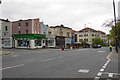
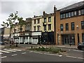
Whiteladies Road
On the opposite side is a bit of a hotchpotch of architectural styles.
Image: © Bill Boaden
Taken: 15 Apr 2017
0.04 miles
10

The W G Grace
A J. D. Wetherspoon pub based on Cliftons famous cricketer.
Clifton College cricket ground, known as The Close, features in a famous poem by Sir Henry Newbolt. It was also the ground where Dr WG Grace, one of the all-time cricketing greats, played his first serious representative match, at the age of 15. Born in 1848, at Downend (then a village and now a suburb of Bristol), Grace scored 14 first-class centuries at The Close, including 221 runs against Middlesex, taking 10 wickets in the same match.
I sampled an excellent mixed grill and suffered a warm pint of Sharp's Doom Bar followed by a mediocre Abbot Ale.
Image: © Richard Hoare
Taken: 25 Jun 2017
0.04 miles