IMAGES TAKEN NEAR TO
Beaufort Road, BRISTOL, BS8 2JZ
Introduction
This page details the photographs taken nearby to Beaufort Road, BS8 2JZ by members of the Geograph project.
The Geograph project started in 2005 with the aim of publishing, organising and preserving representative images for every square kilometre of Great Britain, Ireland and the Isle of Man.

There are currently over 7.5m images from over14,400 individuals and you can help contribute to the project by visiting https://www.geograph.org.uk
Image Map
Images are licensed for reuse under creativecommons.org/licenses/by-sa/2.0
Notes
- Clicking on the map will re-center to the selected point.
- The higher the marker number, the further away the image location is from the centre of the postcode.
Image Listing (286 Images Found)
Images are licensed for reuse under creativecommons.org/licenses/by-sa/2.0
Image
Details
Distance
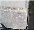
1
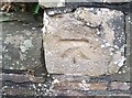
Ordnance Survey Cut Mark
This OS cut mark can be found on the wall Ne side of Osbourne Road. It marks a point 68.757m above mean sea level.
Image: © Adrian Dust
Taken: 2 Jan 2020
0.02 miles
2

Beaufort Road, Clifton
A large tree near the junction with Osborne Road.
Image: © Derek Harper
Taken: 26 Dec 2021
0.02 miles
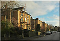
3
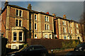
Houses on Beaufort Road, Clifton
Semis between the junctions with Duchess and Osborne Roads.
Image: © Derek Harper
Taken: 26 Dec 2021
0.03 miles
4
Osborne Road, Clifton
From its junction with St John's Road.
Image: © Derek Harper
Taken: 11 Jul 2018
0.04 miles
5

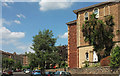
Beaufort Road, Clifton
Houses on the north side of the road.
Image: © Derek Harper
Taken: 11 Jul 2018
0.05 miles
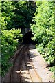
7
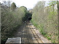
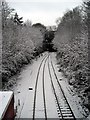
Clifton Down tunnel
View of the railway from St. John's road bridge. The railway enters a long tunnel under Clifton Down on the way to Avonmouth.
Image: © don cload
Taken: 12 Apr 2009
0.06 miles
8
Beaufort Road, Clifton
From the junction with Miles Road, shown in Image
Image: © Derek Harper
Taken: 26 Dec 2021
0.06 miles
9
Ordnance Survey Cut Mark
This OS cut mark can be found on No31 St Johns Road. It marks a point 65.209m above mean sea level.
Image: © Adrian Dust
Taken: 2 Jan 2020
0.06 miles