IMAGES TAKEN NEAR TO
All Saints Road, BRISTOL, BS8 2JG
Introduction
This page details the photographs taken nearby to All Saints Road, BS8 2JG by members of the Geograph project.
The Geograph project started in 2005 with the aim of publishing, organising and preserving representative images for every square kilometre of Great Britain, Ireland and the Isle of Man.

There are currently over 7.5m images from over14,400 individuals and you can help contribute to the project by visiting https://www.geograph.org.uk
Image Map
Images are licensed for reuse under creativecommons.org/licenses/by-sa/2.0
Notes
- Clicking on the map will re-center to the selected point.
- The higher the marker number, the further away the image location is from the centre of the postcode.
Image Listing (280 Images Found)
Images are licensed for reuse under creativecommons.org/licenses/by-sa/2.0
Image
Details
Distance
1
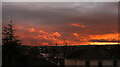
Sunset over North Bristol
Seen from Clarendon Road, with the prominent spires of the Cathedral Church at Clifton and Christ Church.
Image: © Derek Harper
Taken: 16 Mar 2022
0.00 miles
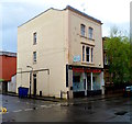
2
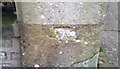
Ordnance Survey Cut Mark
This damaged OS cut mark can be found on the gatepost of No13 All Saints Road. It marks a point 59.032m above mean sea level.
Image: © Adrian Dust
Taken: 2 Jan 2020
0.03 miles
3
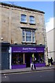
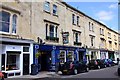
Electrofix guitar shop on Alma Vale Road
Image: © Steve Daniels
Taken: 2 Jun 2011
0.05 miles
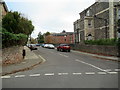
4
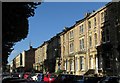
Terraces, Alma Vale Road, Bristol
West of the junction shown in Image
Image: © Derek Harper
Taken: 9 Oct 2016
0.05 miles
5
Bristol Raj, Clifton, Bristol
Indian cuisine restaurant and takeaway at 36 Alma Vale Road, on the corner of Thorndale.
Image: © Jaggery
Taken: 7 May 2012
0.05 miles
7
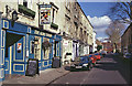
The Alma Tavern, Clifton
This pub on Alma Vale Road incorporates a 50-seat theatre in its former upstairs function room. When this photograph was taken, a production of Mr Kolpert, a play by Diavid Gieselmann, was being advertised.
Image: © Stephen McKay
Taken: Unknown
0.06 miles
8
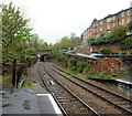
St John's Road bridge viewed from Clifton Down railway station, Bristol
A view west from platform 1.
150 metres beyond the bridge, the railway enters the eastern portal http://www.geograph.org.uk/photo/1249068 of the mile long (1.6km) Clifton Down Tunnel
Image: © Jaggery
Taken: 7 May 2012
0.06 miles
9
The Alma Tavern and Theatre
The theatre was opened in 1997, when two upstairs rooms were converted into the 50 seater auditorium.
Image: © Steve Daniels
Taken: 2 Jun 2011
0.06 miles
10
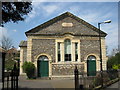
The alma church, Clifton
Now known as alma church (lower case in use), the inscription over the door reads "Clifton Bethesda".
Image: © don cload
Taken: 12 Apr 2009
0.06 miles