IMAGES TAKEN NEAR TO
Alma Vale Road, BRISTOL, BS8 2HT
Introduction
This page details the photographs taken nearby to Alma Vale Road, BS8 2HT by members of the Geograph project.
The Geograph project started in 2005 with the aim of publishing, organising and preserving representative images for every square kilometre of Great Britain, Ireland and the Isle of Man.

There are currently over 7.5m images from over14,400 individuals and you can help contribute to the project by visiting https://www.geograph.org.uk
Image Map
Images are licensed for reuse under creativecommons.org/licenses/by-sa/2.0
Notes
- Clicking on the map will re-center to the selected point.
- The higher the marker number, the further away the image location is from the centre of the postcode.
Image Listing (283 Images Found)
Images are licensed for reuse under creativecommons.org/licenses/by-sa/2.0
Image
Details
Distance
1
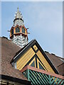
Top of the hall
The parish hall next to All Saints church was converted into residential use. The finer details have been retained, with some complemetary modern work. See Image
Image: © Neil Owen
Taken: 1 Jul 2021
0.01 miles
2
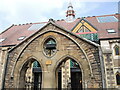
Old entrance to Garden Court
The old parish hall associated with All Saints' church was converted into residential use. Most of the building has been changed, but some features were kept. See Image] for a look at the top of the roof.
Image: © Neil Owen
Taken: 1 Jul 2021
0.01 miles
3
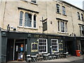
The Alma Tavern and Theatre
Despite the age of the area, the pub/theatre is a fairly recent establishment.
Image: © Neil Owen
Taken: 1 Jul 2021
0.01 miles
4

Garden Court, Clifton, Bristol
Garden Court contains 12 flats, located adjacent to All Saints with St John church. http://www.geograph.org.uk/photo/3447713
Image: © Jaggery
Taken: 7 May 2012
0.01 miles
5
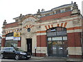
The Edwards Garage
At the end of Alma Vale Road is a remarkable building. It was built in 1898 as a Baroque style garage. This was an unusual as there were very few cars at the time, but the premises were in business for many years. Close by used to be the Corporation depot. See Image] for a closer look at the detail.
Image: © Neil Owen
Taken: 1 Jul 2021
0.02 miles
6
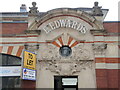
An end to the motor trade here?
Edwards Garage occupies the late nineteenth century building, which was built in 1898 in Baroque style. See Image] for a wider view.
Image: © Neil Owen
Taken: 1 Jul 2021
0.02 miles

8

All Saints Church
From Clifton College Close
Image: © Anthony O'Neil
Taken: 1 May 2020
0.03 miles
9
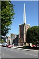
Church of All Saints, Clifton
The Church of All Saints in Clifton was originally designed by George Edmund Street and was built between 1868 and 1872. An incendiary bomb destroyed the chancel and nave of the church on 2 December 1940. In the 1960s the church was restored and in aluminium fleche was placed on top of the tower. The church is Grade II listed, see: https://historicengland.org.uk/listing/the-list/list-entry/1208704?section=official-list-entry
Image: © Philip Halling
Taken: 9 Aug 2022
0.03 miles
10
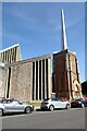
Church of All Saints in Clifton
The Church of All Saints in Clifton was originally designed by George Edmund Street and was built between 1868 and 1872. An incendiary bomb destroyed the chancel and nave of the church on 2 December 1940. In the 1960s the church was restored and in aluminium fleche was placed on top of the tower. The church is Grade II listed, see: https://historicengland.org.uk/listing/the-list/list-entry/1208704?section=official-list-entry
Image: © Philip Halling
Taken: 9 Aug 2022
0.03 miles