IMAGES TAKEN NEAR TO
Osborne Road, BRISTOL, BS8 2HA
Introduction
This page details the photographs taken nearby to Osborne Road, BS8 2HA by members of the Geograph project.
The Geograph project started in 2005 with the aim of publishing, organising and preserving representative images for every square kilometre of Great Britain, Ireland and the Isle of Man.

There are currently over 7.5m images from over14,400 individuals and you can help contribute to the project by visiting https://www.geograph.org.uk
Image Map
Images are licensed for reuse under creativecommons.org/licenses/by-sa/2.0
Notes
- Clicking on the map will re-center to the selected point.
- The higher the marker number, the further away the image location is from the centre of the postcode.
Image Listing (288 Images Found)
Images are licensed for reuse under creativecommons.org/licenses/by-sa/2.0
Image
Details
Distance
1
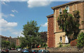
Osborne Road, Clifton
From its junction with St John's Road.
Image: © Derek Harper
Taken: 11 Jul 2018
0.02 miles
2
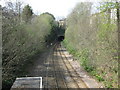
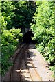
Clifton Down tunnel
View of the railway from St. John's road bridge. The railway enters a long tunnel under Clifton Down on the way to Avonmouth.
Image: © don cload
Taken: 12 Apr 2009
0.02 miles
3
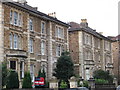
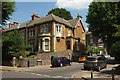
Clifton - Houses on Osborne Road
Two of many big Victorian houses in this part of Bristol.
Image: © Dave Bevis
Taken: 14 Feb 2009
0.02 miles
6
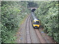
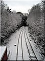
Rain on the train
A local service emerges from the Clifton Down tunnel and gets another soaking.
Image: © Neil Owen
Taken: 2 Aug 2021
0.04 miles
7
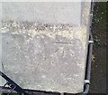
Ordnance Survey Cut Mark
This OS cut mark can be found on No31 St Johns Road. It marks a point 65.209m above mean sea level.
Image: © Adrian Dust
Taken: 2 Jan 2020
0.04 miles
8
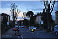
Bristol : St John's Road
A residential road heading through Clifton in Bristol.
Image: © Lewis Clarke
Taken: 24 Mar 2015
0.04 miles
9
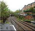
St John's Road bridge viewed from Clifton Down railway station, Bristol
A view west from platform 1.
150 metres beyond the bridge, the railway enters the eastern portal http://www.geograph.org.uk/photo/1249068 of the mile long (1.6km) Clifton Down Tunnel
Image: © Jaggery
Taken: 7 May 2012
0.05 miles
10
House on St John's Road, Clifton
By the junction with Chantry Road.
Image: © Derek Harper
Taken: 11 Jul 2018
0.06 miles