IMAGES TAKEN NEAR TO
St. Johns Road, BRISTOL, BS8 2EZ
Introduction
This page details the photographs taken nearby to St. Johns Road, BS8 2EZ by members of the Geograph project.
The Geograph project started in 2005 with the aim of publishing, organising and preserving representative images for every square kilometre of Great Britain, Ireland and the Isle of Man.

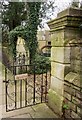
There are currently over 7.5m images from over14,400 individuals and you can help contribute to the project by visiting https://www.geograph.org.uk
Image Map
Images are licensed for reuse under creativecommons.org/licenses/by-sa/2.0
Notes
- Clicking on the map will re-center to the selected point.
- The higher the marker number, the further away the image location is from the centre of the postcode.
Image Listing (322 Images Found)
Images are licensed for reuse under creativecommons.org/licenses/by-sa/2.0
Image
Details
Distance
1
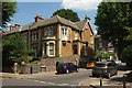
House on St John's Road, Clifton
By the junction with Chantry Road.
Image: © Derek Harper
Taken: 11 Jul 2018
0.02 miles
2
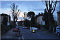
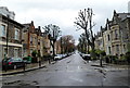
Bristol : St John's Road
A residential road heading through Clifton in Bristol.
Image: © Lewis Clarke
Taken: 24 Mar 2015
0.02 miles
3
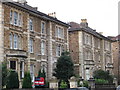
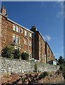
Clifton - Houses on Osborne Road
Two of many big Victorian houses in this part of Bristol.
Image: © Dave Bevis
Taken: 14 Feb 2009
0.04 miles
4
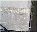
Ordnance Survey Cut Mark
This OS cut mark can be found on No31 St Johns Road. It marks a point 65.209m above mean sea level.
Image: © Adrian Dust
Taken: 2 Jan 2020
0.04 miles
5
No junk mail, Bristol
Odd name for a house. Of course, I wouldn't have noticed it if the gate hadn't been across the pavement. This is on St John's Road, Clifton.
Image: © Derek Harper
Taken: 23 Feb 2014
0.05 miles
6
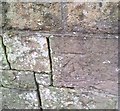
Ordnance Survey Cut Mark
This OS cut mark can be found on SW parapet of the railway bridge on St Johns Road. It marks a point 59.735m above mean sea level.
Image: © Adrian Dust
Taken: 2 Jan 2020
0.05 miles
7
Rear of houses on Whatley Road, Bristol
Overlooking the yard beside Clifton Down Station.
Image: © Derek Harper
Taken: 9 Oct 2016
0.05 miles
8
St John's Road, Clifton, Bristol
This is the southern end of St John's Road, viewed across Alma Vale Road.
Image: © Jaggery
Taken: 7 May 2012
0.06 miles
9
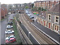
Clifton Down railway station
Track heading west under St Johns road towards Severn Beach.
Image: © Dr Duncan Pepper
Taken: 26 Jan 2009
0.06 miles
10
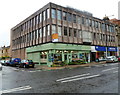
Better Food Company, Whiteladies Road, Bristol
Located on the corner of Hurle Road. Bristol's Better Food Company, an organic food retailer, opened this food hall and deli in October 2010. Their original store and HQ are in Sevier Street, St Werburghs, Bristol.
Image: © Jaggery
Taken: 7 May 2012
0.06 miles