IMAGES TAKEN NEAR TO
Hanbury Road, BRISTOL, BS8 2EP
Introduction
This page details the photographs taken nearby to Hanbury Road, BS8 2EP by members of the Geograph project.
The Geograph project started in 2005 with the aim of publishing, organising and preserving representative images for every square kilometre of Great Britain, Ireland and the Isle of Man.

There are currently over 7.5m images from over14,400 individuals and you can help contribute to the project by visiting https://www.geograph.org.uk
Image Map
Images are licensed for reuse under creativecommons.org/licenses/by-sa/2.0
Notes
- Clicking on the map will re-center to the selected point.
- The higher the marker number, the further away the image location is from the centre of the postcode.
Image Listing (335 Images Found)
Images are licensed for reuse under creativecommons.org/licenses/by-sa/2.0
Image
Details
Distance
1
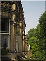
Terrace, Hanbury Road, Clifton
Another view of the terrace shown in Image], dropping down the hill towards Alma Road.
Image: © Derek Harper
Taken: 12 Jul 2013
0.04 miles
2
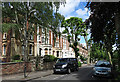
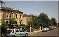
Hanbury Road
There is a long terrace on the north side of tree-lined Hanbury Road, with elaborate bow windows on each house.
Image: © Anne Burgess
Taken: 25 Jun 2017
0.05 miles
3
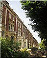
Terrace, Hanbury Road, Clifton
Part of a terrace of 15 properties on the west side of the road.
Image: © Derek Harper
Taken: 12 Jul 2013
0.05 miles
4
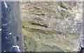
Ordnance Survey Cut Mark
This damaged OS cut mark can be found on the gatepost of No30 Alma Road. It marks a point 57.818m above mean sea level.
Image: © Adrian Dust
Taken: 2 Jan 2020
0.06 miles
5

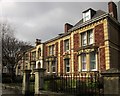
Oakfield Road, Clifton
The Clifton area was developed as a prosperous middle-class 19th century suburb of Bristol, and this fine terrace of houses on Oakfield Road is seen from the corner of Leigh Road. The sunshine and blossom give the feel of an April day, although the picture was taken in February.
Image: © Stephen McKay
Taken: Unknown
0.06 miles
6
Oakfield Road, Clifton
Late Victorian detached villas near Victoria Park. These appear as Westminster Villas on old maps.
Image: © Derek Harper
Taken: 12 Jul 2013
0.06 miles
7
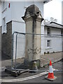
Casualty at the top of Oakfield Grove
A stone pillar has been knocked off its spot, presumably by a motor vehicle.
Image: © Neil Owen
Taken: 1 Jul 2021
0.07 miles
8
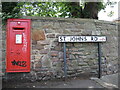
George at St Johns Road
A Georgian letterbox, courtesy of McDowall Steven. Note the graffiti only appears on smooth surfaces, not the stony stuff.
Image: © Neil Owen
Taken: 1 Jul 2021
0.07 miles
9
Oakfield Road, Bristol
A terrace of three, actually linked to an adjoining terrace on the right.
Image: © Derek Harper
Taken: 22 Mar 2015
0.07 miles
10
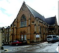
Colkin House, Clifton, Bristol
Office building in the former Pembroke Road Chapel, on the corner of Oakfield Road and Oakfield Grove (about 150 metres east of Pembroke Road). The first church on this site was a tin tabernacle (corrugated metal building) of 1866, painted to look like stone and with a spire c55ft high. This was replaced
by the building seen here, a cruciform church of 1877. After the church closed in the 1930s, it was for a time a garage before conversion to offices. The nameboard shows Whyatt Pakeman Partners Chartered Accountants.
Image: © Jaggery
Taken: 7 May 2012
0.07 miles