IMAGES TAKEN NEAR TO
Alma Road, BRISTOL, BS8 2DE
Introduction
This page details the photographs taken nearby to Alma Road, BS8 2DE by members of the Geograph project.
The Geograph project started in 2005 with the aim of publishing, organising and preserving representative images for every square kilometre of Great Britain, Ireland and the Isle of Man.

There are currently over 7.5m images from over14,400 individuals and you can help contribute to the project by visiting https://www.geograph.org.uk
Image Map
Images are licensed for reuse under creativecommons.org/licenses/by-sa/2.0
Notes
- Clicking on the map will re-center to the selected point.
- The higher the marker number, the further away the image location is from the centre of the postcode.
Image Listing (324 Images Found)
Images are licensed for reuse under creativecommons.org/licenses/by-sa/2.0
Image
Details
Distance
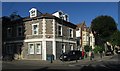
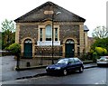
1
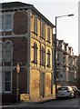
Alma Road, Bristol
The prominent building catching the late sun is shown from the other direction in Image
Image: © Derek Harper
Taken: 27 Oct 2017
0.03 miles
2
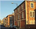
Alma Road, Bristol
Houses catching the evening sunlight; with the junctions with Alma Road Avenue and Sunningdale on the south side of the road.
Image: © Derek Harper
Taken: 27 Oct 2017
0.03 miles
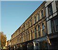
3
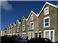
Terrace, Alma Vale Road, Bristol
Eight gables, eight houses in this terrace on a road that ends (behind the camera) at the rear of the Clifton Down shopping centre.
Image: © Derek Harper
Taken: 9 Oct 2016
0.05 miles
4
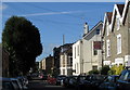
Alma Vale Road, Bristol
The end two gables of the terrace shown in Image] are on the right of this image taken from the same spot, and showing the crossroads with St John's Road.
Image: © Derek Harper
Taken: 9 Oct 2016
0.05 miles
5
Junction of St John's Road with Alma Vale Road
Alma Vale Road is to the left. The corner building at number 62 is now flats; could there have been a shop door is the blank corner wall?
Image: © Derek Harper
Taken: 9 Oct 2016
0.05 miles
6
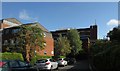
Alma Vale Road, Bristol
Approaching the rear of the Clifton Down shopping centre. On the left are flats at Alma Court.
Image: © Derek Harper
Taken: 9 Oct 2016
0.06 miles
7
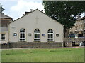
A new part of Alma Church
This side is part of the new building that is home to Alma Church. It replaces for the most part - save the front entrance - the former Brethren Bethesda chapel that stood here for over a century.
Image: © Neil Owen
Taken: 1 Jul 2021
0.06 miles
8
Terrace on Alma Road, Bristol
The low evening sun shines along this terrace, with Whiteladies Road at the end.
Image: © Derek Harper
Taken: 27 Oct 2017
0.07 miles
9
Alma Church, Clifton, Bristol
Alma Church, on the corner of Alma Road and St John's Road, Clifton, is part of the Evangelical Alliance. The inscription on the tablet on the wall is CLIFTON BETHESDA 1871.
It was named Clifton Bethesda to distinguish it from Bethesda Chapel in Great George Street. After this church was destroyed during World War II, the name Bethesda Church replaced Clifton Bethesda.
Its present-day name is derived from its location in Alma Road.
Image: © Jaggery
Taken: 7 May 2012
0.07 miles
10
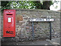
George at St Johns Road
A Georgian letterbox, courtesy of McDowall Steven. Note the graffiti only appears on smooth surfaces, not the stony stuff.
Image: © Neil Owen
Taken: 1 Jul 2021
0.07 miles