IMAGES TAKEN NEAR TO
Belgrave Road, BRISTOL, BS8 2AA
Introduction
This page details the photographs taken nearby to Belgrave Road, BS8 2AA by members of the Geograph project.
The Geograph project started in 2005 with the aim of publishing, organising and preserving representative images for every square kilometre of Great Britain, Ireland and the Isle of Man.

There are currently over 7.5m images from over14,400 individuals and you can help contribute to the project by visiting https://www.geograph.org.uk
Image Map
Images are licensed for reuse under creativecommons.org/licenses/by-sa/2.0
Notes
- Clicking on the map will re-center to the selected point.
- The higher the marker number, the further away the image location is from the centre of the postcode.
Image Listing (270 Images Found)
Images are licensed for reuse under creativecommons.org/licenses/by-sa/2.0
Image
Details
Distance
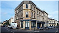
1
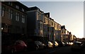
West Park, Bristol
Buildings on the south side of the street, seen from Cotham Hill.
Image: © Derek Harper
Taken: 27 Oct 2017
0.02 miles
2
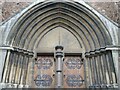
A grand entrance to the old St Mary's
The church has had a varied career but the original features are still outstanding.
Image: © Neil Owen
Taken: 5 Jul 2021
0.03 miles
3
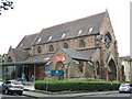
Woodlands Church
Originally St Mary's Church, it was founded in 1871 and is a Grade II listed building. Designs by the celebrated architect James Piers St Aubyn (his only church in Bristol) were difficult to create and not completed fully. A large spire was never constructed, partly due to concerns over the church's stability. In 1909 remedial work by John Bevan had to be made. In 1975, it was joined to other local parishes and was rededicated as St Saviour and St Mary, Cotham.
The church served until 1976, when it was closed as a place of worship. It then became a storage facility for the B.B.C. for some time. In the mid 1990s, it was sold to a free-church community once again and is now the Woodlands Church.
Image: © Neil Owen
Taken: 5 Jul 2021
0.04 miles
4
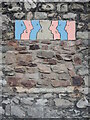
Speaking to one another
A piece of art on a wall along Cotham Hill, giving little indication of what it is about. Is it speaking or is it a Covid comment? Make you own minds up.
Image: © Neil Owen
Taken: 2 Aug 2021
0.04 miles
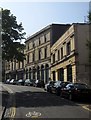
5
Building on corner of Cotham Hill and West Park
In the mid-1980s I lived in a flat in this building above a motorcycle shop called Bristol 6 Scooters, which occupied the nearest 3 shop units. Now all part of a film production business, Films@59.
Image: © David Martin
Taken: 10 Jul 2019
0.04 miles
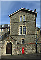
6

Ordnance Survey Cut Mark
This OS cut mark can be found on the gatepost of No14 Belgrave Road. It marks a point 60.052m above mean sea level.
Image: © Adrian Dust
Taken: 14 Mar 2020
0.04 miles
7
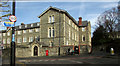
St Joseph's Home, Cotham
A slightly closer view than Image of the home for the elderly poor run by The Little Sisters of the Poor, inspired by the work of Jeanne Jugan (1792-1879) https://www.littlesistersofthepoor.co.uk/information/history/ . The view is across Cotham Hill from Woodland Road. On the wall is Elizabeth II postbox BS6 303.
Image: © Derek Harper
Taken: 19 Feb 2019
0.04 miles
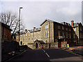
8
St Joseph's Home, Cotham
Another view of the home for the elderly poor run by The Little Sisters of the Poor shown in Image], and Elizabeth II postbox BS6 303.
Image: © Derek Harper
Taken: 19 Feb 2019
0.04 miles
9
Cotham Hill
The street climbs away from Clifton Down, seen from the junction shown in Image
Image: © Derek Harper
Taken: 13 Jul 2013
0.05 miles
10
St Joseph's Home, Cotham
The Little Sisters of the Poor run this home providing day-care and residential care.
Image: © Linda Bailey
Taken: 9 Apr 2006
0.07 miles