IMAGES TAKEN NEAR TO
Priory Road, BRISTOL, BS8 1TU
Introduction
This page details the photographs taken nearby to Priory Road, BS8 1TU by members of the Geograph project.
The Geograph project started in 2005 with the aim of publishing, organising and preserving representative images for every square kilometre of Great Britain, Ireland and the Isle of Man.

There are currently over 7.5m images from over14,400 individuals and you can help contribute to the project by visiting https://www.geograph.org.uk
Image Map
Images are licensed for reuse under creativecommons.org/licenses/by-sa/2.0
Notes
- Clicking on the map will re-center to the selected point.
- The higher the marker number, the further away the image location is from the centre of the postcode.
Image Listing (399 Images Found)
Images are licensed for reuse under creativecommons.org/licenses/by-sa/2.0
Image
Details
Distance
2
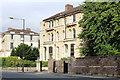
Clifton House, Clifton, Bristol
A very comfortable B&B in a Victorian villa on Tyndall's Park Road.
Free Wi-Fi and more importantly in this vibrant city, free parking for guests.
Image: © Richard Hoare
Taken: 25 Jun 2017
0.05 miles
3
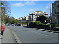
The Big Build vans
These possibly form part of the BBC documentary DIY-SOS featuring Nick Knowles. BBC Bristol is housed in the building behind.
Image: © Richard Hoare
Taken: 26 Jun 2017
0.06 miles
4
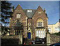
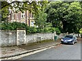
Listed building, Cotham
On Tyndall's Park Road. "c1861. Possibly by Charles Hansom ... Gothic Revival style" https://historicengland.org.uk/listing/the-list/list-entry/1218315 .
Image: © Derek Harper
Taken: 19 Feb 2019
0.06 miles
5
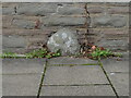
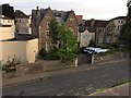
Old Boundary Marker on Tyndall's Park Road, Bristol
Municipal Boundary Marker against a stone wall on the northwest side of Tyndall's Park Road, east of its junction with the A4018 Whiteladies Road. On the former boundary of Bristol St Michael parish in the City of Bristol and Westbury upon Trym parish, but now entirely in Bristol.
Milestone Society National ID: GL_BSWEST08pb
Image: © Roadside Relics
Taken: 11 Nov 2022
0.07 miles
9
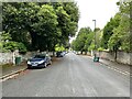
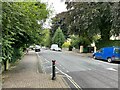
Tyndall's Park Road, Bristol
Tyndall's Park Road leads off Whiteladies Road in the Tyndall's Park district of Bristol. There is a branch of the Allied Irish Bank on the corner. Thomas Tyndall was an 18th century Bristol merchant who purchased land in this area to create an ornamental park; the park was progressively sold off in the 19th century mainly for housing.
Image: © Stephen McKay
Taken: 21 Apr 2018
0.08 miles
10

Ordnance Survey Cut Mark
Only the faintest remains of this OS cut mark can be found on the gatepost of No15 Woodland Road. It marked a point 66.471m above mean sea level.
Image: © Adrian Dust
Taken: 14 Mar 2020
0.08 miles