IMAGES TAKEN NEAR TO
Elmdale Road, BRISTOL, BS8 1SY
Introduction
This page details the photographs taken nearby to Elmdale Road, BS8 1SY by members of the Geograph project.
The Geograph project started in 2005 with the aim of publishing, organising and preserving representative images for every square kilometre of Great Britain, Ireland and the Isle of Man.

There are currently over 7.5m images from over14,400 individuals and you can help contribute to the project by visiting https://www.geograph.org.uk
Image Map
Images are licensed for reuse under creativecommons.org/licenses/by-sa/2.0
Notes
- Clicking on the map will re-center to the selected point.
- The higher the marker number, the further away the image location is from the centre of the postcode.
Image Listing (626 Images Found)
Images are licensed for reuse under creativecommons.org/licenses/by-sa/2.0
Image
Details
Distance
1
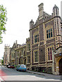
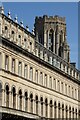
Geography Department, University of Bristol
This is one of the oldest parts of Bristol University. The Geography department is spread over two buildings.
Image: © Linda Bailey
Taken: 12 Jul 2006
0.02 miles
2
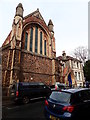
Church of the Nativity of the Mother of God
A Multi-nationality Orthodox Christian community in the heart of Bristol, open to all.
Image: © Eirian Evans
Taken: 4 Mar 2019
0.02 miles
3
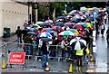
Queue for the Banksy Exhibition
The queue on University Rd for the Banksy exhibition on a rainy wet Monday. The closest part of the queue and the bottom of University Road is in Image The rear part of the queue, the upper part of the street and the museum itself are in Image
Image: © Nigel Mykura
Taken: 5 Aug 2009
0.03 miles
4
Growing room for books and exhibits
A look from University Road at the side of the buildings and the profile of the Wills Memorial tower of the university. Where the bins stop is close to where the nearer buildings are separated. The original museum and library was on the corner of Queens Road, and was extended later; note the slight change in styles and heights as it grew.
Image: © Neil Owen
Taken: 2 Jun 2022
0.03 miles
5
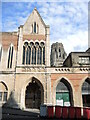
Facade of Royal Promenade
Facade of Royal Promenade on Queen's Road with the Wills Tower in the background. The building was built between 1859 and 68. The architects were John Foster and Joseph Wood. The building is Grade II listed, see: https://historicengland.org.uk/listing/the-list/list-entry/1202477?section=official-list-entry
Image: © Philip Halling
Taken: 9 Aug 2022
0.03 miles
6
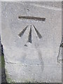
Ordnance Survey Cut Mark
This OS cut mark can be found on the north east face of the museum. It marks a point 56.7903m above mean sea level.
Image: © Adrian Dust
Taken: 5 Mar 2016
0.03 miles
8
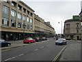
Along Queen's Road
Looking along Queen's Road towards the University.
Image: © DS Pugh
Taken: 25 Jun 2017
0.04 miles
9
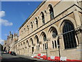
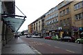
The side of the museum
Originally the museum and library, this fine building was built in the late 1800s. At the time, the road was called Museum Road. Over time, the university became more involved with the development and the building was used as a restaurant.
Image: © Neil Owen
Taken: 2 Jun 2022
0.04 miles
10
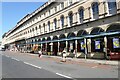
The Royal Promenade on Queen's Road
Shops in the Royal Promenade on Queen's Road. The building was built between 1859 and 1868. The architects were John Foster and Joseph Wood. The building is Grade II listed, see: https://historicengland.org.uk/listing/the-list/list-entry/1202477?section=official-list-entry
Image: © Philip Halling
Taken: 9 Aug 2022
0.04 miles