IMAGES TAKEN NEAR TO
Queens Road, BRISTOL, BS8 1ND
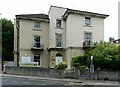
Introduction
This page details the photographs taken nearby to Queens Road, BS8 1ND by members of the Geograph project.
The Geograph project started in 2005 with the aim of publishing, organising and preserving representative images for every square kilometre of Great Britain, Ireland and the Isle of Man.

There are currently over 7.5m images from over14,400 individuals and you can help contribute to the project by visiting https://www.geograph.org.uk
Image Map
Images are licensed for reuse under creativecommons.org/licenses/by-sa/2.0
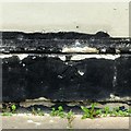
Notes
- Clicking on the map will re-center to the selected point.
- The higher the marker number, the further away the image location is from the centre of the postcode.
Image Listing (431 Images Found)
Images are licensed for reuse under creativecommons.org/licenses/by-sa/2.0
Image
Details
Distance
1
Bristol : Queen's Court
Looking up towards the block of flats on Queen's Road.
Image: © Lewis Clarke
Taken: 19 Jul 2015
0.02 miles
2
Houses on St Paul's Road, Victoria Park
This "Pair of attached houses. c1850" are listed https://www.historicengland.org.uk/listing/the-list/list-entry/1366063 .
Image: © Derek Harper
Taken: 27 Oct 2017
0.02 miles
3
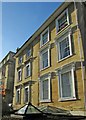
46 & 438 St Paul's Road, Clifton
A pair of neo-classical attached houses, c.1850. Listed Grade II.
Image: © Alan Murray-Rust
Taken: 24 Jun 2017
0.03 miles
4
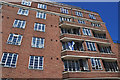
Queen's Court, Queen's Road, Clifton
An imposing block of flats in restrained Art Deco style from c.1936, incorporating a shopping parade at street level. The block follows the curve of the street on this side but is straight along the left hand, St.Paul's Road, side.
Image: © Alan Murray-Rust
Taken: 25 Jun 2017
0.03 miles
5
Bench mark, 92 Queen's Road, Clifton
See http://www.geograph.org.uk/photo/5444593 for location.
Image: © Alan Murray-Rust
Taken: 25 Jun 2017
0.03 miles
6
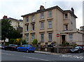
92 & 90 Queen's Road, Clifton
A pair of Victorian houses of less distinction than the majority in the immediate area. There is a bench mark http://www.geograph.org.uk/photo/5444590 on the house, below the 'Clifton' sign board.
Image: © Alan Murray-Rust
Taken: 25 Jun 2017
0.03 miles
7
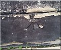
Ordnance Survey Cut Mark
This OS cut mark can be found on No92 Queens Road. It marks a point 60.506m above mean sea level.
Image: © Adrian Dust
Taken: 2 Jan 2020
0.03 miles
8

An old box on St Paul's Road
This Victorian letterbox stands near the end of the road and beside the post-war Queen's Court block of flats. Before the war there was a box right at the junction, a short distance hence; it seems likely that the same box stood there before development.
Image: © Neil Owen
Taken: 1 Jul 2021
0.03 miles
9
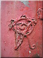
Victoria's cipher
The familiar sign of a Victorian letterbox; it is a Handyside version and stands on St Paul's Road. Maybe a good few layers of Post Office Red paint are starting to peel.
Image: © Neil Owen
Taken: 1 Jul 2021
0.03 miles
10
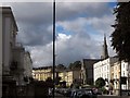
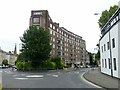
St Paul's Road, Bristol
Seen from the junction with Whiteladies Road. The mid-C19 St Paul's church is described at http://list.english-heritage.org.uk/resultsingle.aspx?uid=1207682&searchtype=mapsearch . The terrace this side of it is of the same era http://list.english-heritage.org.uk/resultsingle.aspx?uid=1207635&searchtype=mapsearch , as are the houses beyond http://list.english-heritage.org.uk/resultsingle.aspx?uid=1202556&searchtype=mapsearch http://list.english-heritage.org.uk/resultsingle.aspx?uid=1366063&searchtype=mapsearch http://list.english-heritage.org.uk/resultsingle.aspx?uid=1366065&searchtype=mapsearch and (the stepped Leicester Terrace) http://list.english-heritage.org.uk/resultsingle.aspx?uid=1202557&searchtype=mapsearch .
Image: © Derek Harper
Taken: 8 Sep 2013
0.03 miles