IMAGES TAKEN NEAR TO
Meridian Place, BRISTOL, BS8 1JL
Introduction
This page details the photographs taken nearby to Meridian Place, BS8 1JL by members of the Geograph project.
The Geograph project started in 2005 with the aim of publishing, organising and preserving representative images for every square kilometre of Great Britain, Ireland and the Isle of Man.

There are currently over 7.5m images from over14,400 individuals and you can help contribute to the project by visiting https://www.geograph.org.uk
Image Map
Images are licensed for reuse under creativecommons.org/licenses/by-sa/2.0
Notes
- Clicking on the map will re-center to the selected point.
- The higher the marker number, the further away the image location is from the centre of the postcode.
Image Listing (561 Images Found)
Images are licensed for reuse under creativecommons.org/licenses/by-sa/2.0
Image
Details
Distance
1
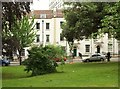
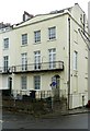
Park Place, Bristol
A triangular square (is that possible?), with a listed terrace "c1790 ... possibly by William Paty" https://www.historicengland.org.uk/listing/the-list/list-entry/1282199 along its eastern side.
Image: © Derek Harper
Taken: 30 Jun 2016
0.01 miles
2
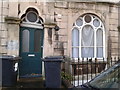
Subsidence or mismatch?
Whatever has caused the two sides of the door to be so poorly aligned with one another, the result is a spectacularly sloping top edge to the door (your photographer was upright!) The unusual circular panes in window and door and the vermiculated carving of the stonework are repeated in other houses along this side of the street (Dover Place).
Image: © HelenK
Taken: 21 Dec 2011
0.01 miles
3
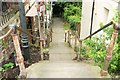
Steps from Meridian Place
Footpath BCC 290/20 is a listed set of steps and walls leading down to Meridian Vale: "Mid C19. Pennant rubble and flags. A series of steps, cobbled each side between rubble walls, doglegged to the SW at the bottom into Meridian Vale" https://www.historicengland.org.uk/listing/the-list/list-entry/1025021 . But, perhaps oddly, the path and steps have no individual name that I can find.
Image: © Derek Harper
Taken: 30 Jun 2016
0.03 miles
4
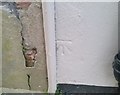
Ordnance Survey Cut Mark
This OS cut mark can be found on No14 Frederick Place. It marks a point 66.029m above mean sea level.
Image: © Adrian Dust
Taken: 2 Jan 2020
0.04 miles
5
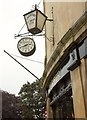
Mr Swanton's Barber Shop, Bristol
A little research suggests this is a barber's with very "traditional" values. The
premises are one of two buildings (part of Bruton Place, a listed terrace https://www.historicengland.org.uk/listing/the-list/list-entry/1202029 of six) that curve around a corner of Park Place, whose trees are in the background.
Image: © Derek Harper
Taken: 30 Jun 2016
0.04 miles
6
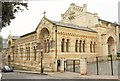
Former Roman Catholic pro-cathedral, Bristol
"Greek Revival-style 1834 work, Northern Italian Gothic Revival-style for 1870 alterations and school" https://www.historicengland.org.uk/listing/the-list/list-entry/1202410 . The earlier work was by H E Goodridge, the later by C Hansom. Pevsner (1958) uses the adjectives "strange" and "alarming". See also http://www.churchcrawler.co.uk/procath.htm . The building later became the Bristol Waldorf School and is now being converted into flats.
Image: © Derek Harper
Taken: 30 Jun 2016
0.04 miles
7
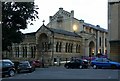
Former Pro-cathedral of the Holy Apostles
The original building to the rear was begun in 1834 to a Greek temple design http://www.churchcrawler.co.uk/procath.htm , but shifting foundations stopped work in 1845. The revised design of 1870 by Hansom included a much lighter structure for the main church and the addition of the complete north (liturgically west) end. After the new Clifton Cathedral was opened in the 1970s, it became a school, then later a store and finally unoccupied. Following threats of demolition, it has finally found a new life as a conversion into student flats. Listed Grade II.
Image: © Alan Murray-Rust
Taken: 24 Jun 2017
0.04 miles
8
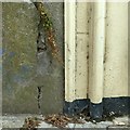
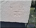
Bench mark, 14 Frederick Place, Clifton
Partly overlaid by modern conduits. See http://www.geograph.org.uk/photo/5444611 for location.
Image: © Alan Murray-Rust
Taken: 25 Jun 2017
0.04 miles
9
14 Frederick Place, Clifton
End house of a terrace of 14, built c.1827, possibly by James Foster. The end house here has a 3-window frontage with shallow pediment compared with 2-window for the rest of the terrace. Listed Grade II, the listing includes the front walls and railings.
There is a bench mark http://www.geograph.org.uk/photo/5444613 on the near corner next to the black downpipe.
Image: © Alan Murray-Rust
Taken: 25 Jun 2017
0.04 miles
10
Ordnance Survey Cut Mark
This OS cut mark can be found on No1 Meridian Place. It marks a point 71.174m above mean sea level.
Image: © Adrian Dust
Taken: 2 Jan 2020
0.04 miles