IMAGES TAKEN NEAR TO
Jacobs Wells Road, BRISTOL, BS8 1DQ
Introduction
This page details the photographs taken nearby to Jacobs Wells Road, BS8 1DQ by members of the Geograph project.
The Geograph project started in 2005 with the aim of publishing, organising and preserving representative images for every square kilometre of Great Britain, Ireland and the Isle of Man.

There are currently over 7.5m images from over14,400 individuals and you can help contribute to the project by visiting https://www.geograph.org.uk
Image Map
Images are licensed for reuse under creativecommons.org/licenses/by-sa/2.0
Notes
- Clicking on the map will re-center to the selected point.
- The higher the marker number, the further away the image location is from the centre of the postcode.
Image Listing (498 Images Found)
Images are licensed for reuse under creativecommons.org/licenses/by-sa/2.0
Image
Details
Distance
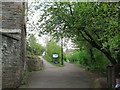
2
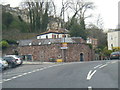
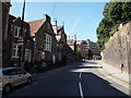
Jacob's Well Road, Bristol
Looking down Jacob's Well Road with the Hope and Anchor pub in the centre of the picture.
Image: © Stephen McKay
Taken: 21 Apr 2018
0.02 miles
3

Ordnance Survey Cut Mark
This OS cut mark can be found on the wall east side of Jacobs Wells Road. It marks a point 28.368m above mean sea level.
Image: © Adrian Dust
Taken: 23 Dec 2019
0.02 miles
4
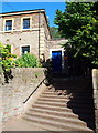
Jacob's Wells Rd - BS8
A stepped entrance into Brandon Hill Park from Jacob's Wells Road. The building seen here is a former Police Station built in 1836, the home to the Avon Wildlife Trust since 1985. The park is very steep in places and is divided into informal gardens, a small nature reserve and areas of open grassland. The two hectare nature reserve has been run by the Avon Wildlife Trust since 1980.
Image: © David Hallam-Jones
Taken: 30 Jul 2012
0.03 miles
5
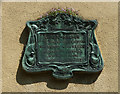
Detail of 2 Bellevue, Bristol
Decorative plaque recording that "Lord Lawrence of the Punjab and his brother Sir Henry Lawrence defender of Lucknow lived in this house in their youth 1819-24" . Erected by the Clifton Improvement Committee.
Image: © Stephen Richards
Taken: 22 May 2012
0.05 miles
6
Jacob's Wells Rd - BS1
A view uphill towards the Berkeley Place section of the Jacob's Wells Road (i.e. the B4466). The stone wall on the right is the boundary wall of the Queen Elizabeth Hospital School, the grounds of which extend up the side of this hill in the direction of the City Library & Art Gallery. The more distant parked car is parked in the shadow of Hill's Almshouses. The pedestrian in the foreground is walking past a building that has all the appearances of a former school although it is now appears to be occupied by independent businesses.
Image: © David Hallam-Jones
Taken: 30 Jul 2012
0.05 miles
7
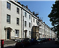
1-19 Bellevue, Bristol
Late-Georgian terrace of two-bay houses, built c1792-1810. The builder-architect was probably William Paty. Grade II listed.
Image: © Stephen Richards
Taken: 22 May 2012
0.05 miles
8
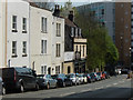
Many moves in Bellevue
Property is hot property in this part of Bristol.
Image: © Neil Owen
Taken: 26 Dec 2021
0.06 miles
9
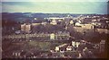
West from Cabot Tower, Bristol, 1966
Looking more to the left than Image], with a corner of the hospital below on the right. Compare with Image, which covers the right half of the image forty years on, and also shows the Clifton Suspension Bridge in the distance across Clifton. The most prominent terrace, crossing from the left, is on Bellevue http://list.english-heritage.org.uk/resultsingle.aspx?uid=1204103&searchtype=mapsearch .
Image: © Derek Harper
Taken: Unknown
0.06 miles
10
Brandon Hill Nature Park
This is the entrance to the park from Jacob's Wells Road.
Image: © don cload
Taken: 12 Apr 2009
0.06 miles