IMAGES TAKEN NEAR TO
Gorse Lane, BRISTOL, BS8 1DH
Introduction
This page details the photographs taken nearby to Gorse Lane, BS8 1DH by members of the Geograph project.
The Geograph project started in 2005 with the aim of publishing, organising and preserving representative images for every square kilometre of Great Britain, Ireland and the Isle of Man.

There are currently over 7.5m images from over14,400 individuals and you can help contribute to the project by visiting https://www.geograph.org.uk
Image Map
Images are licensed for reuse under creativecommons.org/licenses/by-sa/2.0
Notes
- Clicking on the map will re-center to the selected point.
- The higher the marker number, the further away the image location is from the centre of the postcode.
Image Listing (452 Images Found)
Images are licensed for reuse under creativecommons.org/licenses/by-sa/2.0
Image
Details
Distance
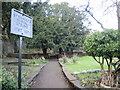
1
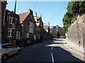
Jacob's Wells Rd - BS1
A view uphill towards the Berkeley Place section of the Jacob's Wells Road (i.e. the B4466). The stone wall on the right is the boundary wall of the Queen Elizabeth Hospital School, the grounds of which extend up the side of this hill in the direction of the City Library & Art Gallery. The more distant parked car is parked in the shadow of Hill's Almshouses. The pedestrian in the foreground is walking past a building that has all the appearances of a former school although it is now appears to be occupied by independent businesses.
Image: © David Hallam-Jones
Taken: 30 Jul 2012
0.02 miles
2
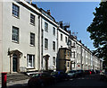
1-19 Bellevue, Bristol
Late-Georgian terrace of two-bay houses, built c1792-1810. The builder-architect was probably William Paty. Grade II listed.
Image: © Stephen Richards
Taken: 22 May 2012
0.03 miles
3
Lower Clifton Hill - BS8
In the lower right-hand corner Bellevue Terrace can be seen joining or leaving Lower Clifton Hill, which in turn joins Jacob's Wells Road. In the background is Queen Elizabeth's Hospital school (a.k.a."QEH"), an independent school for boys that has been located on this site since 1847. Prior to its relocation here it was housed in Gaunt's Hospital mansion house, Unity St (1590-1767) and in St. Bartholomew's Hospital, at the foot of Christmas Steps (1767-1847). Behind the ivy-topped wall is the Hill's Almshouses complex (a.k.a. Stoneleigh House almshouses). It is in Tudor Gothic Revival style and here one of its projecting rear-facing gable ends can be seen linked by a two storey 9-bay cast-iron verandah of arches with trefoils in the spandrels, a panelled screen just below the first-floor windows that look as though they have long been glazed with 20th century glazing. It also looks as though modernised apartments have now been created for somewhat fewer than the original "12 poor women".
Image: © David Hallam-Jones
Taken: 30 Jul 2012
0.04 miles
4

Ordnance Survey Cut Mark
This OS cut mark can be found on No19 Bellevue. It marks a point 53.627m above mean sea level.
Image: © Adrian Dust
Taken: 23 Dec 2019
0.04 miles
5
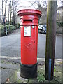
Bellevue box
A Handyside Victorian postbox, still in its original spot.
Image: © Neil Owen
Taken: 26 Dec 2021
0.04 miles
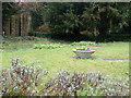
6
The Strangers' Burial Ground
When Bristol's Clifton and Hot Well areas were starting to become popular venues, there followed a chain of events. As the spring waters gained a reputation for curative powers and the wealthy burghers settled in a fashionable spot, it attracted many other desperate patients who were from outside the city walls. Inevitably, the waters did not cure them all and those who perished here, far from home, were buried in this small cemetery. It served as an overflow to the (now demolished) St Paul's church.
However, with the growing population came local sewage problems and the effluent eventually found its way into the very waters that were claimed to cure illnesses. With its reputation shot to ribbons, the custom of taking the waters soon stopped, and with it the area's fall from favour. The burial grounds operated for nearly a century in sympathy. Today it is being restored to some of its glory and is a public space when open.
Image: © Neil Owen
Taken: 26 Dec 2021
0.04 miles
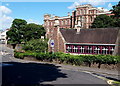
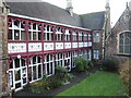
7
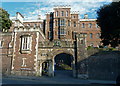
Queen Elizabeth's Hospital school, Bristol
Queen Elizabeth's Hospital (more commonly known as QEH) is an independent school for boys near Brandon Hill, founded in 1586.
Image: © Anthony O'Neil
Taken: 14 Mar 2011
0.04 miles
8
Strangers' Burial Ground
An overflow graveyard for St Paul's Church, Clifton (now demolished), it was closed in 1871. It contains the grave of Thomas Beddoes, an English physician and scientific writer who worked to treat tuberculosis. https://en.wikipedia.org/wiki/Thomas_Beddoes
Image: © Eirian Evans
Taken: 4 Mar 2019
0.05 miles
9
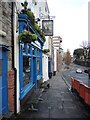
The Eldon House
A pub at the end of Lower Clifton Hill.
Image: © Neil Owen
Taken: 26 Dec 2021
0.05 miles
10
Stoneleigh House
Formerly the almshouses founded by Thomas William Hill, Esq., in 1868. The land was donated by the Society of Merchant Venturers and the houses designed by Charles Hansom. It was originally intended to house twelve poor women but these days is a supported living facility specialising in mental health care. Grade II listed.
Image: © Neil Owen
Taken: 26 Dec 2021
0.05 miles