IMAGES TAKEN NEAR TO
Bonnington Walk, BRISTOL, BS7 9XF
Introduction
This page details the photographs taken nearby to Bonnington Walk, BS7 9XF by members of the Geograph project.
The Geograph project started in 2005 with the aim of publishing, organising and preserving representative images for every square kilometre of Great Britain, Ireland and the Isle of Man.

There are currently over 7.5m images from over14,400 individuals and you can help contribute to the project by visiting https://www.geograph.org.uk
Image Map (Loading...)


Getting Data...Please wait
Leaflet Map data © OpenStreetMap
Images are licensed for reuse under creativecommons.org/licenses/by-sa/2.0
Notes
- Clicking on the map will re-center to the selected point.
- The higher the marker number, the further away the image location is from the centre of the postcode.
Image Listing (31 Images Found)
Images are licensed for reuse under creativecommons.org/licenses/by-sa/2.0
Image
Details
Distance
1
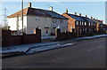
Frosty side of Bonnington Walk, Bristol
Overnight hoar frost remains on surfaces not yet reached by the rays of sun.
Image: © Jaggery
Taken: 29 Dec 2013
0.02 miles
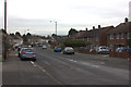
3
Junction of Bonnington Walk and Concorde Way, Bristol
Looking across Bonnington Walk along Concorde Way which leads to Bishopston RFC (rugby football club).
Image: © Jaggery
Taken: 29 Dec 2013
0.04 miles
4
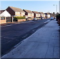
Contrasting sides of Bonnington Walk, Bristol
Overnight hoar frost remains on surfaces not yet reached by the rays of sun.
Image: © Jaggery
Taken: 29 Dec 2013
0.05 miles
5
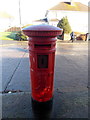
Edwardian postbox in Bonnington Walk, Bristol
Located near the corner of Landseer Avenue. The ornate Edward VII monogram
dates the box to 1901 to 1910. The aperture is unsealed, so the box appears
to be in use despite the absence of the collection times notice.
Image: © Jaggery
Taken: 29 Dec 2013
0.07 miles
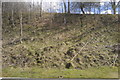
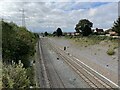
7
Track beside railway
Passing under Boonington Walk - looking north.
Image: © JThomas
Taken: 2 Apr 2013
0.08 miles
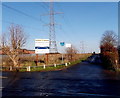
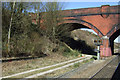
8
Bonnington Walk railway bridge, Bristol
The bridge carries Bonnington Walk over railway lines about a kilometre SSW of Filton Abbey Wood railway station. Horfield railway station, which closed in 1964, was located immediately to the south (left) of the bridge.
Overnight hoar frost remains on surfaces not yet reached by the rays of sun.
Image: © Jaggery
Taken: 29 Dec 2013
0.09 miles
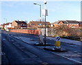
9
Horfield railway station (site), Bristol
Opened in 1927 by the Great Western Railway on the line from Bristol to South Wales, this station closed in 1964 and was dismantled.
View south towards Ashley Hill and Bristol. The line had been recently quadrupled (again) when this image was taken.
Image: © Nigel Thompson
Taken: 25 Sep 2021
0.09 miles
10

Horfield Cutting
Passenger train in the cutting at Horfield.
Image: © Wayland Smith
Taken: 2 Jun 2007
0.09 miles