IMAGES TAKEN NEAR TO
Bonnington Walk, BRISTOL, BS7 9XD
Introduction
This page details the photographs taken nearby to Bonnington Walk, BS7 9XD by members of the Geograph project.
The Geograph project started in 2005 with the aim of publishing, organising and preserving representative images for every square kilometre of Great Britain, Ireland and the Isle of Man.

There are currently over 7.5m images from over14,400 individuals and you can help contribute to the project by visiting https://www.geograph.org.uk
Image Map
Images are licensed for reuse under creativecommons.org/licenses/by-sa/2.0
Notes
- Clicking on the map will re-center to the selected point.
- The higher the marker number, the further away the image location is from the centre of the postcode.
Image Listing (47 Images Found)
Images are licensed for reuse under creativecommons.org/licenses/by-sa/2.0
Image
Details
Distance
1
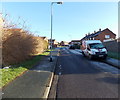
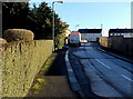
Virgin Media van in Stothard Road, Bristol
Viewed from the Bonnington Walk end.
Overnight hoar frost remains on surfaces not yet reached by the rays of sun.
Image: © Jaggery
Taken: 29 Dec 2013
0.05 miles
2
Bonnington Walk SE of an Edwardian postbox, Bristol
Viewed from here. http://www.geograph.org.uk/photo/3796260
Image: © Jaggery
Taken: 29 Dec 2013
0.06 miles
3
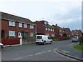
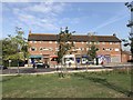
Highmore Gardens
These red brick terraced social housing are part of the stock of housing in North Bristol that was once council housing.
Image: © Nigel Mykura
Taken: 23 Feb 2013
0.09 miles
4
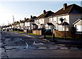
Landseer Road houses, Bristol
Viewed across Bonnington Walk looking SSW.
Image: © Jaggery
Taken: 29 Dec 2013
0.10 miles
5
Branwhite Close, Bristol
Branwhite Close is a 90 metre long cul-de-sac on the east side of Bonnington Walk.
Overnight hoar frost remains on surfaces not yet reached by the rays of sun.
Image: © Jaggery
Taken: 29 Dec 2013
0.12 miles
6
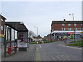
Gainsborough Square
This square is interesting from a Geograph point of view as it covers the corners of four separate grid squares. This is the northwest corner of the square. the square is surrounded with blocks of apartments with shops on the lowest level such as this McColls newsagent, off-licence and convenience store.
Image: © Nigel Mykura
Taken: 23 Feb 2013
0.12 miles
8
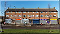
Row of shops on the west side of Gainsborough Square, Lockleaze, Bristol
All closed and shuttered on a Sunday morning.
Image: © Jaggery
Taken: 29 Dec 2013
0.13 miles
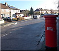
9
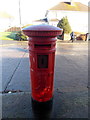
Edwardian postbox in Bonnington Walk, Bristol
Located near the corner of Landseer Avenue. The ornate Edward VII monogram
dates the box to 1901 to 1910. The aperture is unsealed, so the box appears
to be in use despite the absence of the collection times notice.
Image: © Jaggery
Taken: 29 Dec 2013
0.13 miles
10
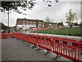
Gainsborough Square, Lockleaze
With re-paving work going on. Gridlines meet within the square, parts of which therefore occupy four squares.
Image: © Derek Harper
Taken: 29 Sep 2014
0.13 miles