IMAGES TAKEN NEAR TO
Romney Avenue, BRISTOL, BS7 9TB
Introduction
This page details the photographs taken nearby to Romney Avenue, BS7 9TB by members of the Geograph project.
The Geograph project started in 2005 with the aim of publishing, organising and preserving representative images for every square kilometre of Great Britain, Ireland and the Isle of Man.

There are currently over 7.5m images from over14,400 individuals and you can help contribute to the project by visiting https://www.geograph.org.uk
Image Map
Images are licensed for reuse under creativecommons.org/licenses/by-sa/2.0
Notes
- Clicking on the map will re-center to the selected point.
- The higher the marker number, the further away the image location is from the centre of the postcode.
Image Listing (44 Images Found)
Images are licensed for reuse under creativecommons.org/licenses/by-sa/2.0
Image
Details
Distance
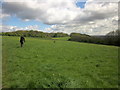
1
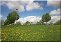
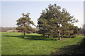
Edge of Stoke Park
Where the corner of an adventure playground impinges on the grassland.
Image: © Derek Harper
Taken: 29 Apr 2015
0.09 miles
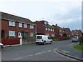
2
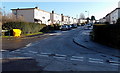
Danby Street, Bristol
Hmm, this is all fields on Google Maps. But there seem to be houses here.
Image: © Derek Harper
Taken: 29 Sep 2014
0.12 miles
3
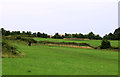
2011 : North in Stoke Park, Lockleaze
A public area behind Romney Avenue. Signs of encroaching development.
Image: © Maurice Pullin
Taken: 2 Aug 2011
0.13 miles
4
Stoke Park
Looking in the opposite direction from the same spot as Image], with a path through an old field boundary. On the left can be seen the radio mast shown in Image
Image: © Derek Harper
Taken: 29 Apr 2015
0.13 miles
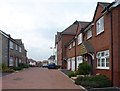
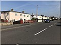
5
Highmore Gardens
These red brick terraced social housing are part of the stock of housing in North Bristol that was once council housing.
Image: © Nigel Mykura
Taken: 23 Feb 2013
0.13 miles
6
Stoke Park
A wider view than Image, taken further west.
Image: © Derek Harper
Taken: 29 Apr 2015
0.14 miles
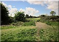
8
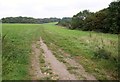
Stoke Park
Footpath BCC/81 runs along the hillside towards Long Wood. In the foreground it crosses footpath BCC/80.
Image: © Derek Harper
Taken: 29 Sep 2014
0.14 miles
10
Hogarth Road, Bristol
Viewed from the Landseer Avenue end.
Overnight hoar frost remains on surfaces not yet reached by the rays of sun.
Image: © Jaggery
Taken: 29 Dec 2013
0.15 miles