IMAGES TAKEN NEAR TO
Dovercourt Road, BRISTOL, BS7 9SF
Introduction
This page details the photographs taken nearby to Dovercourt Road, BS7 9SF by members of the Geograph project.
The Geograph project started in 2005 with the aim of publishing, organising and preserving representative images for every square kilometre of Great Britain, Ireland and the Isle of Man.

There are currently over 7.5m images from over14,400 individuals and you can help contribute to the project by visiting https://www.geograph.org.uk
Image Map
Images are licensed for reuse under creativecommons.org/licenses/by-sa/2.0
Notes
- Clicking on the map will re-center to the selected point.
- The higher the marker number, the further away the image location is from the centre of the postcode.
Image Listing (17 Images Found)
Images are licensed for reuse under creativecommons.org/licenses/by-sa/2.0
Image
Details
Distance
1
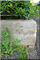
Benchmark on boundary wall of Dovercourt Road Day Centre
Ordnance Survey cut mark benchmark described on the Bench Mark Database at http://www.bench-marks.org.uk/bm57119
Image: © Roger Templeman
Taken: 3 May 2014
0.06 miles
2
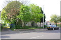
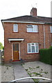
Dovercourt Road Day Centre
There is an OS benchmark Image on the angle of the low concrete wall on the face towards the track on the left hand side of the image
Image: © Roger Templeman
Taken: 3 May 2014
0.07 miles
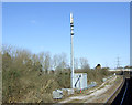
3
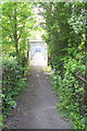
Footpath from Brangwyn Grove over railway
Image: © Roger Templeman
Taken: 3 May 2014
0.13 miles
4

Saturday morning football at Muller Road Recreation Ground
Image: © Eirian Evans
Taken: 24 Apr 2021
0.13 miles
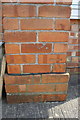
5
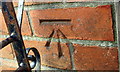
Benchmark on #48 Elmore Road
Ordnance Survey cut mark benchmark described on the Bench Mark Database at http://www.bench-marks.org.uk/bm57118
Image: © Roger Templeman
Taken: 3 May 2014
0.14 miles
6
#48 Elmore Road
There is an OS benchmark Image on the left hand side of the house near its front corner
Image: © Roger Templeman
Taken: 3 May 2014
0.14 miles
8
Benchmark on buttress of #242 Dovercourt Road
Ordnance Survey cut mark benchmark described on the Bench Mark Database at http://www.bench-marks.org.uk/bm57120
Image: © Roger Templeman
Taken: 3 May 2014
0.15 miles
9
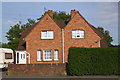
Semi-detached houses on Dovercourt Road
There is an OS benchmark Image on a buttress on the left hand side of the left hand house
Image: © Roger Templeman
Taken: 3 May 2014
0.15 miles