IMAGES TAKEN NEAR TO
Bromley Road, BRISTOL, BS7 9JE
Introduction
This page details the photographs taken nearby to Bromley Road, BS7 9JE by members of the Geograph project.
The Geograph project started in 2005 with the aim of publishing, organising and preserving representative images for every square kilometre of Great Britain, Ireland and the Isle of Man.

There are currently over 7.5m images from over14,400 individuals and you can help contribute to the project by visiting https://www.geograph.org.uk
Image Map (71 Images)


Getting Data...Please wait
Leaflet Map data © OpenStreetMap
Images are licensed for reuse under creativecommons.org/licenses/by-sa/2.0
Notes
- Clicking on the map will re-center to the selected point.
- The higher the marker number, the further away the image location is from the centre of the postcode.
Image Listing (71 Images Found)
Images are licensed for reuse under creativecommons.org/licenses/by-sa/2.0
Image
Details
Distance
1
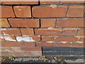
Ordnance Survey Cut Mark
This OS cut mark can be found on No67 Springfield Avenue. It marks a point 44.373m above mean sea level.
Image: © Adrian Dust
Taken: 1 Jul 2022
0.04 miles
2
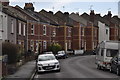
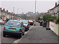
Bristol : Bromley Road
Looking along Bromley Road with houses alongside it.
Image: © Lewis Clarke
Taken: 24 Mar 2015
0.04 miles
3
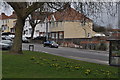
Bristol : Muller Road
A road and a small patch of grass alongside it.
Image: © Lewis Clarke
Taken: 24 Mar 2015
0.05 miles
4
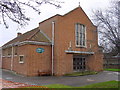
Horfield United Reformed Church
The original church which is to the left of this photograph (now used as the church hall) was built in 1933 and was originally called the Muller Road Congregational Church. This church was built in 1957.
The sign above the door says Whitefield Memorial Tabernacle.
Image: © Linda Bailey
Taken: 5 Jan 2006
0.06 miles
5
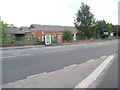
Closed Bus Depot, Muller Road, Horfield (1)
Taken from Springfield Avenue, this photo shows the closed bus depot in Muller Road BS7 9ND. It would appear to have dated from the 1950s and was originally operated by the Bristol Omnibus Co.Ltd housing, at one time, over 100 buses for services to the North of Bristol. A bus shelter can be seen in front of this depot. Update: this bus garage has since been demolished and a planning application submitted for a superstore with car parking facilities to be built on this site.
Image: © David Hillas
Taken: 1 Jun 2017
0.09 miles
6
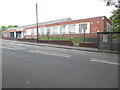
Closed Bus Depot, Muller Road, Horfield (3)
Taken from Muller Road, this photo shows the closed bus depot with its future almost certain to end with demolition, as it is unlikely that it will reopen due to structural problems with the building. Certainly, it seems to have seen better days as it was a busy bus depot in years gone by, housing over 100 vehicles at one time. However, it is quite possible that another bus depot will open in due course to the North of Bristol. A bus shelter can be seen to the right of the photo. Update: this bus garage has since been demolished and a planning application been submitted for a superstore with car parking spaces to be built on this site.
Image: © David Hillas
Taken: 1 Jun 2017
0.10 miles
7
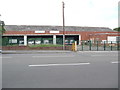
Closed Bus Depot, Muller Road, Horfield (2)
This photo shows the bus depot in Muller Road BS7 9ND housing withdrawn single-decker buses. Following its closure in July 2010, buses have been housed at Hengrove (ST 5969 refers) and Lawrence Hill (ST 6073) for Bristol city services. Update: this bus garage has since been demolished and a planning application submitted for a superstore with car parking facilities to be built on this site.
Image: © David Hillas
Taken: 1 Jun 2017
0.10 miles
8
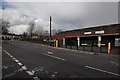
Bristol : Muller Road B4469
A road heading through the Redland area of Bristol.
Image: © Lewis Clarke
Taken: 24 Mar 2015
0.11 miles
9
Ordnance Survey Cut Mark
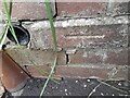
This OS cut mark can be found on the wall of No34 Bromley Road. It marks a point 48.323m above mean sea level.
Image: © Adrian Dust
Taken: 1 Jul 2022
0.12 miles
10
Dovercourt Road
Looking south down Dovercourt Road, with the Muller Orphanage on the horizon.
Image: © Linda Bailey
Taken: 5 Jan 2006
0.12 miles