IMAGES TAKEN NEAR TO
Queens Road, BRISTOL, BS7 9HY
Introduction
This page details the photographs taken nearby to Queens Road, BS7 9HY by members of the Geograph project.
The Geograph project started in 2005 with the aim of publishing, organising and preserving representative images for every square kilometre of Great Britain, Ireland and the Isle of Man.

There are currently over 7.5m images from over14,400 individuals and you can help contribute to the project by visiting https://www.geograph.org.uk
Image Map (Loading...)


Getting Data...Please wait
Leaflet Map data © OpenStreetMap
Images are licensed for reuse under creativecommons.org/licenses/by-sa/2.0
Notes
- Clicking on the map will re-center to the selected point.
- The higher the marker number, the further away the image location is from the centre of the postcode.
Image Listing (73 Images Found)
Images are licensed for reuse under creativecommons.org/licenses/by-sa/2.0
Image
Details
Distance
1
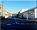
Ralph Road, Bristol
Viewed across Ashley Down Road. Brookfield Garage http://www.geograph.org.uk/photo/3945681 is on the right.
Image: © Jaggery
Taken: 29 Dec 2013
0.04 miles
2
Queens Road, Bristol BS7
Viewed across Ashley Down Road.
Image: © Jaggery
Taken: 29 Dec 2013
0.04 miles
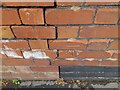
3
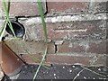
Ordnance Survey Cut Mark
This OS cut mark can be found on the wall of No34 Bromley Road. It marks a point 48.323m above mean sea level.
Image: © Adrian Dust
Taken: 1 Jul 2022
0.07 miles
4
Talgarth Road, Ashley Down, Bristol
Viewed across Ashley Down Road looking along Talgarth Road towards Ashgrove Road.
Image: © Jaggery
Taken: 29 Dec 2013
0.08 miles
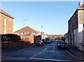
6
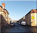
Bromley Road, Bristol BS7
Long lines of cars (and a van) are parked in Bromley Road on a Sunday afternoon in December 2013. Viewed across Ashley Down Road. Foresters Arms http://www.geograph.org.uk/photo/3945822 is on the left.
Image: © Jaggery
Taken: 29 Dec 2013
0.08 miles
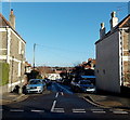
7
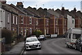
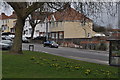
Bristol : Bromley Road
Looking along Bromley Road with houses alongside it.
Image: © Lewis Clarke
Taken: 24 Mar 2015
0.08 miles
8
Ordnance Survey Cut Mark
This OS cut mark can be found on No67 Springfield Avenue. It marks a point 44.373m above mean sea level.
Image: © Adrian Dust
Taken: 1 Jul 2022
0.08 miles
9
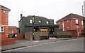
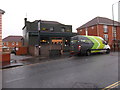
The Lazy Dog, Ashley Down Road
"The pub was first open in 1851 by Job Gillam, the sawyer from Gillam’s Saw Mills situated behind the pub. In the old days the logs were sawed in pairs, the sawyer atop the log was the Top Dog and the one below The Underdog" http://www.barwarsltd.com/the-lazy-dog/about/ - the pub sign shows the underdog taking a break.
Ashley Down Road is the B4052.
Image: © Derek Harper
Taken: 15 Nov 2013
0.09 miles
10
Bristol : Muller Road
A road and a small patch of grass alongside it.
Image: © Lewis Clarke
Taken: 24 Mar 2015
0.09 miles