IMAGES TAKEN NEAR TO
Ashley Down Road, BRISTOL, BS7 9BU
Introduction
This page details the photographs taken nearby to Ashley Down Road, BS7 9BU by members of the Geograph project.
The Geograph project started in 2005 with the aim of publishing, organising and preserving representative images for every square kilometre of Great Britain, Ireland and the Isle of Man.

There are currently over 7.5m images from over14,400 individuals and you can help contribute to the project by visiting https://www.geograph.org.uk
Image Map
Images are licensed for reuse under creativecommons.org/licenses/by-sa/2.0
Notes
- Clicking on the map will re-center to the selected point.
- The higher the marker number, the further away the image location is from the centre of the postcode.
Image Listing (90 Images Found)
Images are licensed for reuse under creativecommons.org/licenses/by-sa/2.0
Image
Details
Distance
1
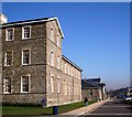
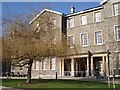
City of Bristol College, Ashley Down
The College buildings were originally the Muller Orphanages founded and built by George Muller (b. 1805 at Kroppenstadt and died Bristol 1898). He settled in Bristol in 1832. It is reported that Muller's orphanages enabled over 120,000 children to be educated in the course of his life. He provided a Christian education and was involved in missionary work.
Thanks to N Dasso for the following detail about George Muller :
"George writes in his journal which is published in a wonderful book called, “ The autobiography of George Müller,” on December 5, 1850, “ most other charitable institutions for orphans make the admission of a destitute orphan very difficult, if not impossible, if they do not have an influential person to sponsor them. In our case, nothing is needed but application to me. The poorest person, without influence, without friends, without any expense, no matter where he lives or which denomination he is affiliated with, may be admitted. Since it is difficult for poor people to get their orphan relatives admitted into ordinary establishments, I feel called to be the friend of the orphan."
This picture is another view of the restored buildings at Ashley Down, looking towards the entrance in the distance.
See also:
http://www.geograph.org.uk/photo/689512
http://www.geograph.org.uk/photo/689548
http://www.geograph.org.uk/photo/689501
Image: © Tom Jolliffe
Taken: 13 Feb 2008
0.00 miles
2
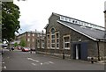
Rear of Cabot House, Ashley Down
A view along the northern side of Image In the foreground is a western wing with a Venetian window. Built in 1870. "Cabot House was the fifth and last of the large barrack-type orphanage buildings to be built from 1847 to 1870 by the Prussian-born pastor and philanthropist George Muller." http://www.imagesofengland.org.uk/Details/Default.aspx?id=469977&mode=adv See also Image The buildings are on a grand scale; Cabot House alone is almost 200 metres in length.
Image: © Derek Harper
Taken: 10 Jul 2009
0.02 miles
3
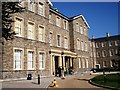
Cabot House, City of Bristol College, Ashley Down
Cabot House is named after a famous Bristolian, John Cabot, an Italian-born explorer who sailed from Bristol to Newfoundland. These buildings once served as an institute for orphans. Many of the windows are placed high in the walls. It is said that the purpose of this was to prevent the children from being distracted. Nowadays these buildings serve a happier purpose, housing, amongst other courses, those designed to enable students to study to gain entrance Higher Education. See also:
http://www.geograph.org.uk/photo/689531
http://www.geograph.org.uk/photo/689512
http://www.geograph.org.uk/photo/689548
Image: © Tom Jolliffe
Taken: 13 Feb 2008
0.04 miles
4
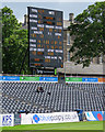
Bristol: the scoreboard at Nevil Road
The main scoreboard is in the eastern corner of the Gloucestershire County Cricket Ground. On the third afternoon of a largely tedious drawn match, it showed two things of particular interest: Nottinghamshire's Samit Patel was on 203, on his way to a career-best 257 not out, the match's highlight, while Gloucestershire's over rate stood at +10 (a real rarity).
Gloucestershire 303 and 254 for 5, Nottinghamshire 535 for 8 declared. Match drawn.
Image: © John Sutton
Taken: 11 Jun 2017
0.04 miles
5
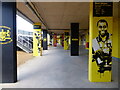
Street art portraits at Gloucestershire's County Cricket ground
The ground, known at time of posting as the Seat Unique Stadium, has distinctive street art all around the ground. The likenesses of players are, in this fan's opinion, excellent.
Image: © Ruth Sharville
Taken: 26 Oct 2022
0.05 miles
6
Pollarded trees, Sefton Park Road
Pollarding is a pruning system involving the removal of the upper branches of a tree, to promote a dense head of foliage and branches. The practice has occurred commonly in Europe since medieval times and takes place today in urban areas to maintain trees at a predetermined height.
Image: © Eirian Evans
Taken: 21 Feb 2018
0.06 miles
7
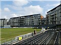
Flats at the Ashley Down Road end of Gloucestershire CCC's ground, Bristol
See Image for an image of the stand that was demolished to enable these dwellings to be built when the ground was redeveloped.
Image: © Ruth Sharville
Taken: 29 Apr 2022
0.08 miles
8

The old Jessop Tavern and Stand, Gloucestershire County Cricket Club
The ground, at Nevil Road, Bristol, has since been redeveloped, and there are now flats Image where this stand used to be.
Image: © Ruth Sharville
Taken: 6 Sep 2012
0.08 miles
9
Davy House, City of Bristol College, Ashley Down
Another building in the restored complex of buildings which originally served as an institute for orphans. The College has housed its Higher Education courses on this site. Major re-development is continuing on other parts of the campus.
See also:
http://www.geograph.org.uk/photo/689548
http://www.geograph.org.uk/photo/689501
http://www.geograph.org.uk/photo/689531
Image: © Tom Jolliffe
Taken: 13 Feb 2008
0.08 miles
10
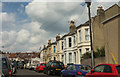
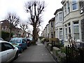
Osborne Avenue, Bristol
A cul-de-sac off Ashley Down Road; at least, I don't think Happy Lane, a path cutting across the end of the road, can be followed by vehicles to the outside world.
Image: © Derek Harper
Taken: 7 May 2019
0.08 miles