IMAGES TAKEN NEAR TO
Ashley Down Road, BRISTOL, BS7 9BQ
Introduction
This page details the photographs taken nearby to Ashley Down Road, BS7 9BQ by members of the Geograph project.
The Geograph project started in 2005 with the aim of publishing, organising and preserving representative images for every square kilometre of Great Britain, Ireland and the Isle of Man.

There are currently over 7.5m images from over14,400 individuals and you can help contribute to the project by visiting https://www.geograph.org.uk
Image Map
Images are licensed for reuse under creativecommons.org/licenses/by-sa/2.0
Notes
- Clicking on the map will re-center to the selected point.
- The higher the marker number, the further away the image location is from the centre of the postcode.
Image Listing (125 Images Found)
Images are licensed for reuse under creativecommons.org/licenses/by-sa/2.0
Image
Details
Distance
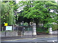
2
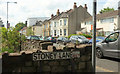
Ashley Down Road
The B4052 at the junction with Williamson Road (left).
Image: © Derek Harper
Taken: 7 May 2019
0.02 miles
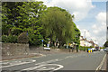
3
Raising the roof, Ashley Down Road
Extending upwards
Image: © Eirian Evans
Taken: 21 Sep 2017
0.03 miles
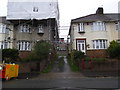
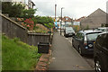
4
Osborne Avenue, Bristol
A cul-de-sac off Ashley Down Road; at least, I don't think Happy Lane, a path cutting across the end of the road, can be followed by vehicles to the outside world.
Image: © Derek Harper
Taken: 7 May 2019
0.08 miles
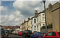
5
Ashley Down Road
As is obvious, taken from the top of Stoney Lane, which carries footpath BCC 205/30 down into Ashley Vale.
Image: © Derek Harper
Taken: 7 May 2019
0.08 miles
6
Ashley Vale Allotments
The western corner of the allotments shown in https://www.geograph.org.uk/search.php?i=108232949 , seen from Ashley Hill. Houses on Mina Road are below.
Image: © Derek Harper
Taken: 7 May 2019
0.09 miles
7
Williamson Road, Bristol
Ahead on the right is Scout Hut 6388, beside the entrance to Clark & Taylor Motors yard.
Image: © Derek Harper
Taken: 7 Sep 2019
0.09 miles
8
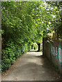
Stoney Lane
Footpath BCC 205/30 follows this lane from Ashley Down Road down into Ashley Vale. There's vehicle access to a back alley just ahead on the right, serving houses on the main road and Kathdene Gardens.
Image: © Derek Harper
Taken: 7 May 2019
0.10 miles
9
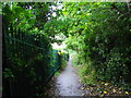
Footpath to Ashley Hill from St Werburgh's
Image: © Eirian Evans
Taken: 21 Sep 2017
0.10 miles
10
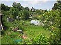
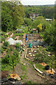
Ashley Vale allotments
"Ashley Vale Allotments consist of 214 plots of varying sizes on a site of 13 acres (5.3 hectares) ... The association was founded in 1917" www.ashleyvaleallotmentsassociation.org .
Image: © Derek Harper
Taken: 28 May 2015
0.11 miles