IMAGES TAKEN NEAR TO
Balmoral Road, BRISTOL, BS7 9AX
Introduction
This page details the photographs taken nearby to Balmoral Road, BS7 9AX by members of the Geograph project.
The Geograph project started in 2005 with the aim of publishing, organising and preserving representative images for every square kilometre of Great Britain, Ireland and the Isle of Man.

There are currently over 7.5m images from over14,400 individuals and you can help contribute to the project by visiting https://www.geograph.org.uk
Image Map
Images are licensed for reuse under creativecommons.org/licenses/by-sa/2.0
Notes
- Clicking on the map will re-center to the selected point.
- The higher the marker number, the further away the image location is from the centre of the postcode.
Image Listing (117 Images Found)
Images are licensed for reuse under creativecommons.org/licenses/by-sa/2.0
Image
Details
Distance
1
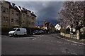
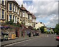
Bristol : Balmoral Road
A road heading off from Hurlingham Road.
Image: © Lewis Clarke
Taken: 24 Mar 2015
0.04 miles
2
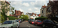
Balmoral Road, Bristol
A similar view to Image, looking around the corner a little more.
Image: © Derek Harper
Taken: 7 May 2019
0.04 miles
3
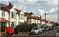
Balmoral Road, Bristol
Semis along the road shown in Image
Image: © Derek Harper
Taken: 7 May 2019
0.05 miles
4
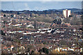
Bristol : City Scenery
From Balmoral Road looking out across the city skyline.
Image: © Lewis Clarke
Taken: 24 Mar 2015
0.06 miles
5
Hurlingham Road, Bristol
Dropping towards the junction with the B4052 Ashley Hill. But you can't go straight there by car; the road is only passable for cyclists and pedestrians as it is blocked just after the next junction, with Wolferton Road.
The houses face a steep railway cutting.
Image: © Derek Harper
Taken: 28 May 2015
0.06 miles
6
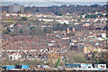
Bristol : City Scenery
Looking out across the rooftops and suburbs of Bristol.
Image: © Lewis Clarke
Taken: 24 Mar 2015
0.07 miles
7
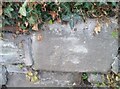
Ordnance Survey Cut Mark
This OS cut mark can be found on the wall of No76 Chesterfield Road. It marks a point 55.705m above mean sea level.
Image: © Adrian Dust
Taken: 9 Oct 2021
0.08 miles
8
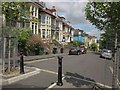
Hurlingham Road, Bristol
In the foreground is the vehicle barrier mentioned at Image Beyond, the road descends to the junction with the B4052 Ashley Hill. Ahead is the junction with Sommerville Road South.
Image: © Derek Harper
Taken: 28 May 2015
0.08 miles
9
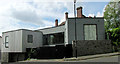
House on Sommerville Road South, Bristol
A 2015 house that won the 2016 Daily Telegraph Home Building & Renovating Award for Most Inspiring Home http://media.rightmove.co.uk/24k/23297/65567774/23297_7673042_DOC_02_0000.pdf .
Image: © Derek Harper
Taken: 7 May 2019
0.08 miles
10
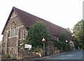
St Bartholomew's Church hall in St Andrews, Bristol
The church hall is situated on Somerville road adjacent to the church.
Image: © Sharon Loxton
Taken: 7 Jul 2006
0.09 miles