IMAGES TAKEN NEAR TO
Hurlingham Road, BRISTOL, BS7 9AS
Introduction
This page details the photographs taken nearby to Hurlingham Road, BS7 9AS by members of the Geograph project.
The Geograph project started in 2005 with the aim of publishing, organising and preserving representative images for every square kilometre of Great Britain, Ireland and the Isle of Man.

There are currently over 7.5m images from over14,400 individuals and you can help contribute to the project by visiting https://www.geograph.org.uk
Image Map
Images are licensed for reuse under creativecommons.org/licenses/by-sa/2.0
Notes
- Clicking on the map will re-center to the selected point.
- The higher the marker number, the further away the image location is from the centre of the postcode.
Image Listing (119 Images Found)
Images are licensed for reuse under creativecommons.org/licenses/by-sa/2.0
Image
Details
Distance
1
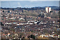
Bristol : City Scenery
From Balmoral Road looking out across the city skyline.
Image: © Lewis Clarke
Taken: 24 Mar 2015
0.01 miles
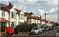
2
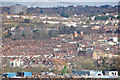
Bristol : City Scenery
Looking out across the rooftops and suburbs of Bristol.
Image: © Lewis Clarke
Taken: 24 Mar 2015
0.02 miles
3
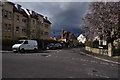
Bristol : Balmoral Road
A road heading off from Hurlingham Road.
Image: © Lewis Clarke
Taken: 24 Mar 2015
0.02 miles
4
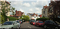
Balmoral Road, Bristol
A similar view to Image, looking around the corner a little more.
Image: © Derek Harper
Taken: 7 May 2019
0.02 miles
5
Balmoral Road, Bristol
Semis along the road shown in Image
Image: © Derek Harper
Taken: 7 May 2019
0.03 miles
6
Bristol : Saint Andrews Road
A small residential road off of Cromwell Road.
Image: © Lewis Clarke
Taken: 24 Mar 2015
0.05 miles
7
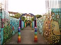
Rainbow foot bridge
The foot bridge crosses the Severn Beach railway not far to the east of Montpelier station. It connects Fairlawn road to the south with Hurlingham road to the north.
Image: © Sharon Loxton
Taken: 7 Jul 2006
0.06 miles
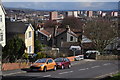
8
St Andrew's Hill
Looking south to Montpelier
Image: © Eirian Evans
Taken: 20 Feb 2018
0.06 miles
9
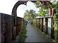
Rainbow bridge
Footbridge over the railway connecting Hurlingham Road and Fairlawn Road
Image: © Eirian Evans
Taken: 18 Sep 2015
0.06 miles
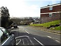
10
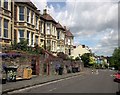
Hurlingham Road, Bristol
Dropping towards the junction with the B4052 Ashley Hill. But you can't go straight there by car; the road is only passable for cyclists and pedestrians as it is blocked just after the next junction, with Wolferton Road.
The houses face a steep railway cutting.
Image: © Derek Harper
Taken: 28 May 2015
0.07 miles