IMAGES TAKEN NEAR TO
Derby Road, BRISTOL, BS7 9AQ
Introduction
This page details the photographs taken nearby to Derby Road, BS7 9AQ by members of the Geograph project.
The Geograph project started in 2005 with the aim of publishing, organising and preserving representative images for every square kilometre of Great Britain, Ireland and the Isle of Man.

There are currently over 7.5m images from over14,400 individuals and you can help contribute to the project by visiting https://www.geograph.org.uk
Image Map (Loading...)


Getting Data...Please wait
Leaflet Map data © OpenStreetMap
Images are licensed for reuse under creativecommons.org/licenses/by-sa/2.0
Notes
- Clicking on the map will re-center to the selected point.
- The higher the marker number, the further away the image location is from the centre of the postcode.
Image Listing (132 Images Found)
Images are licensed for reuse under creativecommons.org/licenses/by-sa/2.0
Image
Details
Distance
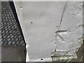
1
Ordnance Survey Cut Mark
This OS cut mark can be found on No55 The Avenue. It marks a point 58.125m above mean sea level.
Image: © Adrian Dust
Taken: 1 Jul 2022
0.04 miles
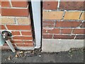
2
Ordnance Survey Cut Mark
This damaged OS cut mark can be found on the gatepost of No83 Somerville Road. It marks a point 62.600m above mean sea level.
Image: © Adrian Dust
Taken: 1 Jul 2022
0.06 miles
3
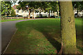
St Andrew's Park, Bristol
A path curves around the northern side of the park, with houses on Sommerville Road in the background.
Image: © Derek Harper
Taken: 12 Sep 2018
0.07 miles
4
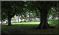
St Andrew's Park, Bristol
The northeast, and highest, sector of the park, with houses on Sommerville Road in the background.
Image: © Derek Harper
Taken: 15 Aug 2017
0.07 miles
5
Bristol Central Tennis Club
Bristol Central Tennis Club is tucked away in a quiet location near St. Andrews Park in central Bristol. 'Central' was established in 1932 and renovated in 1999 and has four floodlit courts.
Image: © Eirian Evans
Taken: 21 Feb 2018
0.07 miles
6
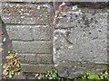
Ordnance Survey Cut Mark
This damaged OS cut mark can be found on the wall of No48 Sefton Park Road. It marks a point 61.984m above mean sea level.
Image: © Adrian Dust
Taken: 1 Jul 2022
0.07 miles
7
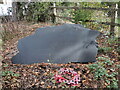
Memorial to a lost Wellington
During WWII, St Andrew's park was the scene of a terrible crash. A Vickers Wellington twin-engined bomber, returning home from a night raid, flew into a barrage balloon site near Purdown. With the aircraft being dragged by a cable wrapped around the wing and losing height rapidly, the bomber skimmed the houses just down the road; its cable caught on trees in the park and brought the 'Wimpy' down in it.
Of the six crewmen, three were killed and the others injured. Local people and a policeman ran to the crash and, braving burning fuel and exploding ordnance, rescued the survivors. The names are recorded on this stone
Image: © Neil Owen
Taken: 11 Oct 2022
0.08 miles
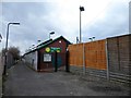
8
The paint carries on inside
The exterior of the toilet block has some typical Bristol style, some of which appears to continue inside too.
Image: © Neil Owen
Taken: 11 Oct 2022
0.08 miles
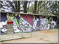
9
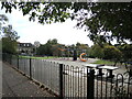
Play area at the top of St Andrew's park
The park was created in the late 1800s, but only had children's play equipment installed from 1946. This separated section now has modern kit for the little ones.
Image: © Neil Owen
Taken: 11 Oct 2022
0.09 miles
10
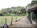
Bristol St Andrew's Bowling Club
The rink inside the park. The club was founded in 1924 and, thanks to a Sport England grant, now has floodlighting for evening matches throughout the season.
Image: © Neil Owen
Taken: 11 Oct 2022
0.10 miles