IMAGES TAKEN NEAR TO
Gloucester Road, BRISTOL, BS7 8TN
Introduction
This page details the photographs taken nearby to Gloucester Road, BS7 8TN by members of the Geograph project.
The Geograph project started in 2005 with the aim of publishing, organising and preserving representative images for every square kilometre of Great Britain, Ireland and the Isle of Man.

There are currently over 7.5m images from over14,400 individuals and you can help contribute to the project by visiting https://www.geograph.org.uk
Image Map (Loading...)


Getting Data...Please wait
Leaflet Map data © OpenStreetMap
Images are licensed for reuse under creativecommons.org/licenses/by-sa/2.0
Notes
- Clicking on the map will re-center to the selected point.
- The higher the marker number, the further away the image location is from the centre of the postcode.
Image Listing (72 Images Found)
Images are licensed for reuse under creativecommons.org/licenses/by-sa/2.0
Image
Details
Distance
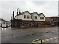
3
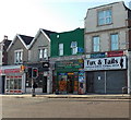
Tux & Tails, Horfield, Bristol
The formal wear hire and retail shop on the right is at 372 Gloucester Road.
Heaven Food & Wine convenience store is next door.
Image: © Jaggery
Taken: 29 Dec 2013
0.04 miles
4
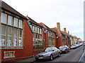
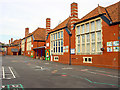
Ashley Down Infant School
Ashley Down Infant School on the left, looking up Tortworth Road towards the Gloucester Road (A38).
Image: © Linda Bailey
Taken: 11 Feb 2006
0.04 miles
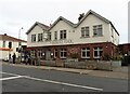
6
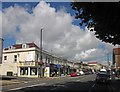
Gloucester Road, Horfield
An alternative view of the stretch of the A38 shown in Image
Image: © Derek Harper
Taken: 18 Aug 2013
0.06 miles
7
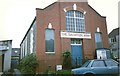
Salvation Army, Ashley Down Road
The former Salvation Army hall in Ashley Down Road, home of the Bristol Horfield corps for nearly 100 years from 1901 to 1999. The building, a former Methodist chapel, is now in residential usage.
Image: © Rob K Brettle
Taken: Unknown
0.06 miles
8
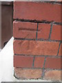
Benchmark on Ashley Hall
Extensive building work is in progress as the Hall is converted to flats. The Ordnance Survey cut mark benchmark, which is surviving between the scaffolding poles, is described on the Bench Mark Database at http://www.bench-marks.org.uk/bm28939.
Image: © Roger Templeman
Taken: 14 Aug 2010
0.06 miles
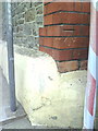
9
Ordnance Survey Cut Mark
This OS cut mark can be found on the Salvation Army building on Ashley Down Road. It marks a point 54.797m above mean sea level.
Image: © Adrian Dust
Taken: 3 Mar 2016
0.06 miles
10
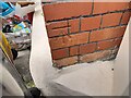
Ordnance Survey Cut Mark
This OS cut mark can be found on the Salvation Army Hall on Ashley Down Road. It marks a point 54.797m above mean sea level.
Image: © Adrian Dust
Taken: 1 Jul 2022
0.06 miles