IMAGES TAKEN NEAR TO
Maple Road, BRISTOL, BS7 8RF
Introduction
This page details the photographs taken nearby to Maple Road, BS7 8RF by members of the Geograph project.
The Geograph project started in 2005 with the aim of publishing, organising and preserving representative images for every square kilometre of Great Britain, Ireland and the Isle of Man.

There are currently over 7.5m images from over14,400 individuals and you can help contribute to the project by visiting https://www.geograph.org.uk
Image Map (Loading...)


Getting Data...Please wait
Leaflet Map data © OpenStreetMap
Images are licensed for reuse under creativecommons.org/licenses/by-sa/2.0
Notes
- Clicking on the map will re-center to the selected point.
- The higher the marker number, the further away the image location is from the centre of the postcode.
Image Listing (67 Images Found)
Images are licensed for reuse under creativecommons.org/licenses/by-sa/2.0
Image
Details
Distance
1
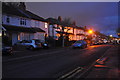
Bristol : Maple Road
Looking along Maple Road in Bristol.
Image: © Lewis Clarke
Taken: 24 Mar 2015
0.02 miles
2
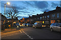
Radnor Rd
This is the Western end of Radnor Rd looking west towards its junction with Maple Rd.
Image: © Nigel Mykura
Taken: 12 Jun 2010
0.02 miles
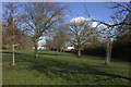
3
Path into Horfield Common from Longmead Avenue
Image: © Robert Eva
Taken: 27 Feb 2020
0.03 miles
4
Bristol : Maple Road
Looking along Maple Road from the junction with Radnor Road.
Image: © Lewis Clarke
Taken: 24 Mar 2015
0.04 miles
5
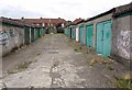
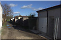
Garages, Horfield Common
At the southwest corner of Horfield Common by the path to Maple Road.
Image: © Derek Harper
Taken: 10 Jul 2009
0.05 miles
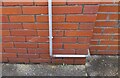
8
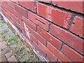
Ordnance Survey Cut Mark
This OS cut mark can be found on No109 Longmead Avenue. It marks a point 64.380m above mean sea level.
Image: © Adrian Dust
Taken: 1 Jul 2022
0.09 miles
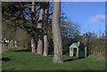
9

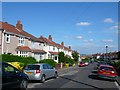
Longmead Avenue, Horfield
Semis along a road near Horfield Prison.
Image: © Derek Harper
Taken: 2 May 2016
0.09 miles
10
Ordnance Survey Cut Mark
This OS cut mark can be found on No139 Longmead Avenue. It marks a point 72.567m above mean sea level.
Image: © Adrian Dust
Taken: 1 Jul 2022
0.09 miles